Follow our liveblog for the latest updates on the storm and flash flooding.
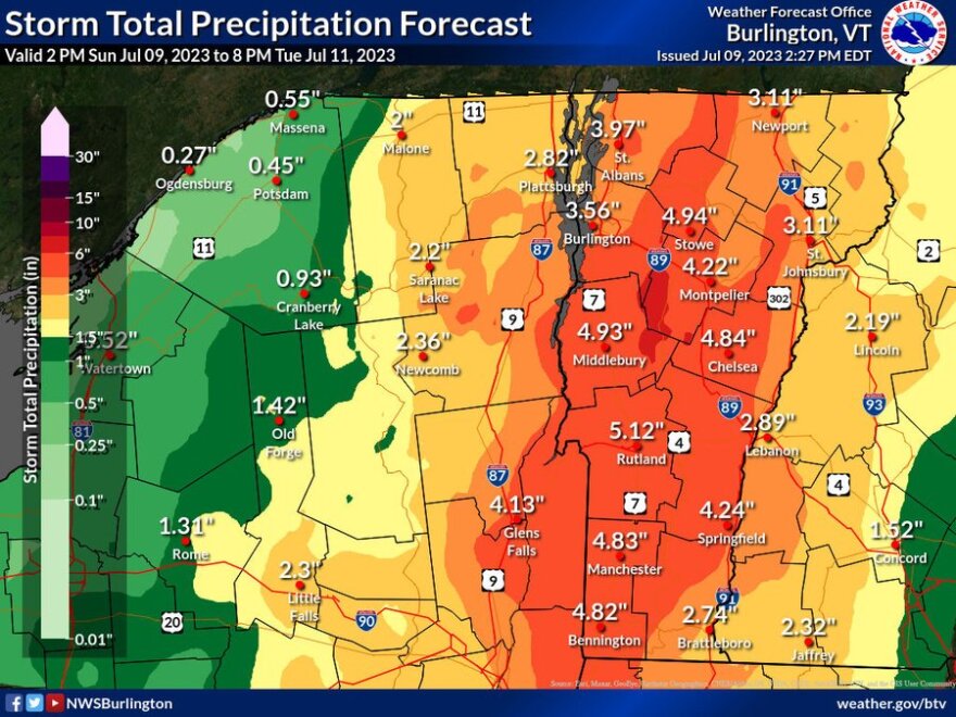
Significant flash flooding is likely tonight into Monday evening as a storm brings an estimated 2 to 5 inches of rainfall to Vermont.
"It's definitely a serious event," said Peter Banacos, a meteorologist at the National Weather Service's Burlington office. "We're expecting probably the worst flash flooding we've seen since Hurricane Irene struck the region, and that was in 2011."
The National Weather Service issued a flood watch covering all parts of Vermont and Clinton, Essex and Franklin counties across the lake in New York.
The weather service predicted the highest amounts of rain along the Green Mountains, including over 5 inches of rainfall predicted for Rutland. There could be local areas that receive up to 7 or 8 inches, Banacos said in an interview Sunday afternoon.
What makes this storm serious is that it's moving slowly — Banacos said the storm is moving north — and can drop rain for prolonged periods. In addition, there's tropical airmass already in place over Vermont, and soils are already saturated. Rain will not absorb into the soil, but will go immediately into runoff.
Forecasters expect rivers to flood Monday night into Tuesday, especially along main stem rivers such as Otter Creek and the Winooski River in Vermont and the Ausable River in New York.

Gov. Phil Scott declared a state of emergency ahead of the storm, which would allow Vermont to request help from other states. Vermont's emergency operations center has been activated, and state agencies are monitoring the storm. Swiftwater rescue teams are also staged across the state to help as needed.
"We've got a long 36 to 48 hours ahead of us," Banacos said.
Be prepared
The National Weather Service and Vermont Emergency Management offer these tips:
- Monitor the latest weather and water level reports. (Check forecasts from the NWS Albany office for Bennington and Windham counties and the NWS Burlington office for the rest of the state.)
- Vermont Alert is one way to get the latest emergency notifications on your phone or email.
- Have a plan for your evacuation route if rising water is approaching.
- Find road closure information on the New England 511 website or on Twitter at @511VT.
- Never drive or walk through flooded roads or areas.
- If you live in a flood-prone area, move valuables from your basement.
Flooding is expected across the region this evening and overnight. Nighttime flooding is especially dangerous because flood waters can be difficult to see. Travelers should use extreme caution and remain alert for rapidly changing conditions. #vtwx #nywx pic.twitter.com/hJZh97NBOu
— NWS Burlington (@NWSBurlington) July 9, 2023
Follow our liveblog for the latest updates on the storm and flash flooding.
Have questions, comments or tips? Send us a message.


