
Live updates: Major flooding causes road closures and evacuations across Vermont


In some places Vermonters are waiting for water levels to drop while in others they're beginning to survey the damage following significant flooding across the state. Check back here for the latest updates.
Note: Find the latest updates on Vermont's recovery starting July 12 here. This live blog is inactive.
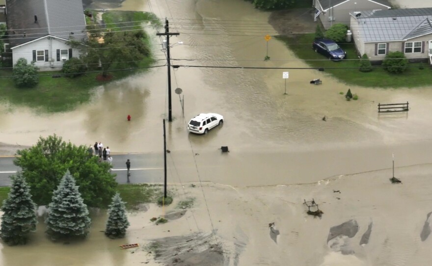
River flooding shut down entire communities in Vermont on Tuesday and officials urged residents to wait in safe locations until waters can crest and begin to recede.
Links to key resources:
- For road closure information, visit newengland511.org or @511VT on Twitter.
- More than 3,100 electric customers were out of power as of Tuesday afternoon, with the most outages in Washington County. Find power outage information at vtoutages.org.
- School activities and child care programs announced closures.
- Find flood-prone areas near you with the Vermont Flood Ready Atlas.
- Find the latest forecasts and water levels for specific rivers from the National Weather Service.
- Get tips on what to expect when returning home after a flood.
- To find more resources and other services, call Vermont 2-1-1 or visit vermont211.org.
Enter your email to sign up for The Frequency
Vermont Public's daily news update, sent weekday mornings.
Some older Vermonters evacuated, but not nursing facilities

Officials from the Vermont Department of Aging and Independent Living say no skilled nursing facilities in Vermont have needed to be evacuated.
But dozens of older Vermonters have had to leave their homes because of flooding.
Local officials in Chelsea say they safely moved 24 seniors out of the Riverbend Residential Care home and into a local church late Monday.
Sixty miles north, Donald Lange and his wife Margaret were among 27 residents evacuated today from Mann’s Meadow senior apartments in Jeffersonville.
“Five o’clock this morning my wife was looking out the window and two pickup trucks came in and went out no problem, and an hour and a half later there was water everywhere,” said Donald. “Cambridge Fire Department came in and helped us out the back, and they had several buses waiting for us.”

Lange, who is also a local health officer in Cambridge, said several of his neighbors use walkers and wheelchairs. He said some had to be convinced they needed to leave. But he added they all made it safely through rising water to Cambridge Elementary School.
Smugglers' Notch Resort has offered to house any in the group who don’t have other options.
Surveying the damage in the town of Weston

The storm this week left extensive damage around the center of Weston.
The land behind the post office, for example, is completely washed out.
Melvin Twitchell is the postmaster in town, and says there are roads all over Weston that were damaged by the rain.
"We didn’t come in yesterday. Today it will not get delivered because we can’t get to any roads," Twitchell said. "Right now it’s not safe, so safety is one of our factors."
The maintenance manager at the Weston Playhouse, which has its theater in the center of town, says the damage to the theater was worse than during Tropical Storm Irene.
The theater group is trying to figure out how they’ll salvage their summer season.
Montpelier dam waters stopped rising earlier this afternoon
Montpelier officials say water levels at a dam near the city have not risen during the early afternoon — that comes after water came within a foot of the top of the Wrightsville Dam.
Earlier this morning, city officials said the dam was close to spilling over and potentially increasing flooding in downtown Montpelier.

According to a press release from the city, the onsite Vermont Dam Safety Representative believes only minimal increases in the water level are expected.
City officials say they'll continue to monitor the dam throughout the night.
Quechee residents reflect on flood levels and damage

Quechee continues to be hard-hit by the extreme flooding coming from the Ottauquechee River Tuesday morning.
Nearby building Simon Pearce was evacuated Monday evening after water breached the river's banks. CEO Jay Benson is hoping that despite electrical damage and other repairs needed, retail and restaurant operations could start back up, "knock on wood," in a week or two.
Benson said one of the bright spots is all of the support — locally and nationally — that they're receiving. Overall, Benson said it could've been worse.
"It's sad, but it's Mother Nature so, you know, I think in some ways we're a lot more fortunate than people who lost their houses and other things like that, so we're very grateful that everyone was safe," Benson said.
Benson is looking forward to being back open to the public after cleaning up.

Chip Jameson owns a real estate business in Quechee, and was dealing with flood impacts in his lower-level storefront on Tuesday morning. Jameson said he was glad to have a heads up about the storm yesterday, otherwise the damage could have been much worse.
"It stalled over Killington," Jameson said. "And then we heard a report that Bridgewater had just gotten a big surge and that would be here in 20 minutes. So you know, we're all having fun, anticipating and moving stuff out, trying to get things up above, hoping it doesn't get too high. So we really dodged a little bit of a bullet."
Frank Medora has lived in the area for 14 years and vividly remembers Tropical Storm Irene.
"So two hurricanes now. This was supposed to be a 100-year scenario. And it's only 11 years. Tells you something," Medora said.
Despite the Irene-level flooding and damage across the state, and as high as the Ottauquechee River got yesterday, Jameson said the town was much better prepared compared to 12 years ago.
"It was not anywhere near what Irene was," Jameson said. "Redoing the covered bridge was the big part of it. It just opened everything up to let drain right out."
Flooding safety advice in 16 languages
The Vermont Language Justice Project has provided the following videos to help Vermonters stay safe during heavy rain events:
عربي
မြန်မာ
دری
English (closed captions):
Français
Kirundi
Maay Maay
普通话
नेपाली
په پښتو
Soomaali
Español
Kiswahili
Tiếng Việt
Tigrinia
українська
Waterbury residents frustrated by floodwaters not going down
Water rose overnight in the town of Waterbury, flooding some neighborhoods and blocking roadways. And the water level is staying high.
Gary Dillon is the Waterbury fire chief. He says residents are beginning to feel frustrated and helpless.
"People are just waiting for the water to recede before people can get into their houses and offload water. You can’t pump water out of your basement into water that’s going into your basement," he said. "It’s a vicious cycle right now until the water starts going down, and right now it’s going back up."
Some residents canoed to their homes Tuesday. Among them was Brian Kravitz, who lives along Randall Street in downtown, which was covered in about two feet of water this morning.
He says at this point, the damage to his home is just in the basement, and that so far, this flood is not as bad as during Tropical Storm Irene in 2011.
"Irene was really a one-day event, 6 a.m. the next day water had receded," Kravitz said. "This one, the water had gone down some, and now it’s come up another 5-6 inches again. Looks like it’ll be quite a while."
Water levels remain below where they were during Irene, but officials warn they could still rise.
Hardwick remains widely inaccessible Tuesday

Hardwick continues to face significant flooding causing most of the area to be inaccessible due to road flooding.
As of 10:30 a.m. Tuesday, there was only one back road from the east into Hardwick — Route 15, which still requires taking several backroads to access.
Hardwick Town Manager David Upson said they are moving forward.
"We're starting to build up, haul gravel and build the roads back up, though we still have the shelter open. Water system seems to be going well. Machinery is cooking. We've served several meals," Upson said.
Upson also said, on top of the road closures, that there are propane tanks "hissing everywhere." During major flooding, propane may become unavailable and cause other issues, which has been a concern across the state this week.
Tara Reese worked with Upson, whom locals also know as Opie, to organize the Hardwick shelter up at Hazen Union High School. Reese said driving from Danville to Hardwick on Monday night to reach the shelter "felt pretty precarious at the time" due to road closures.
Reese said a few people had arrived at the shelter by ambulance last night due to the road closures making it impossible for them to reach a hospital.
"It was a very sobering realization to think that you know, oh, yeah, you can't get to a hospital," Reese said.
Reese also noted other damages. A motel that had been evacuated Monday was completely swept out by flood waters.
Reese said the shelter will be open again tonight, and that a team will be making a large lunch for the group.
Ashton Allen, the commander of the sons of the American Legion in Hardwick, is out assessing damage.
Allen predicts around 30 to 40 people were at the Hazen shelter last night, and said that if there are any roads in Hardwick open, "they're not in very good shape."
"Don't try to come into Hardwick because you can't get here. If you know people, call and check on them, but pray for us," Allen said.
Volunteers help bail out Londonderry church

The entire basement of Second Congregational Church in Londonderry was flooded in the storm with about 3-4 inches of water.
Pastor Laurie Krooss and volunteers were cleaning up Tuesday morning with sump pumps and buckets.
"It's worse than Hurricane Irene in 2011," Krooss said. "The water was higher and stayed longer," Krooss said.

The church's largest fundraiser sale is scheduled to happen in two weeks. It's unclear, Krooss said, if that can happen.
Krooss said if people want to donate to Londonderry Relief, they should consider the Stratton Foundation and Neighborhood Connections.
Takeaways from Gov. Phil Scott's 11 a.m. press conference
Gov. Phil Scott, in a media briefing Tuesday morning, urged Vermonters to remain vigilant and follow directives from public safety officials as communities across the state grapple with widespread flooding and washed out roads.
“Make no mistake, the devastation and flooding we are experiencing across Vermont is historic and catastrophic,” Scott said. “Floodwaters continue to rise in some places like our capital city, and have surpassed the levels seen during Tropical Storm Irene.”
Administration officials say Vermont is still at the earliest stages of this disaster and that evacuations and rescues are ongoing.
And Scott issued a stark warning to Vermonters this morning that the emergency was far from over.
“Even though the sun may shine later today and tomorrow, we expect more rain later this week which will have nowhere to go in the oversaturated ground,” Scott said. “So I want to be clear — we are not out of the woods.”
Scott administration officials held a media briefing Tuesday at 11 a.m. offering an update on the ongoing flooding battering Vermont. Here are some of the key takeaways:
- As of 9:30 a.m. officials say there have been no reported injuries or deaths.
- There have been more than 100 swift water rescues so far.
- The Vermont National Guard has deployed in conjunction with Vermont Emergency Management to help with search and rescue operations. The National Guard will use helicopters to conduct search and rescue operations in hard hit, remote areas that can’t be accessed by the swift water teams.
- Rescues are actively happening. There are six out-of-state urban search and rescue teams operating in Vermont and officials say they expect search and rescue operations to last for at least several days.
- At least 78 roads across the state are closed, though state officials say Interstate-89 both northbound and southbound have reopened.
- Please don’t try to help by traveling into flooded areas. “For now, please focus your volunteer energy at the hyper local level,” said Jennifer Morrison, commissioner of public safety. “Check on your neighbors and the most vulnerable in your neighborhood.” You can register at vermont.gov/volunteer to help with future volunteer efforts.
LIVE: Scott administration briefing on flooding in Vermont
For the second day in a row, the governor and members of his cabinet are delivering a briefing on the flooding and its impacts now.
You catch it on Vermont Public by radio, smartspeaker or online stream or watch here:
Mad River in Moretown did not cause evacuations Monday

Residents in Moretown who were in danger of flooding from the Mad River did not have to evacuate Monday night.
About 30 homes in the downtown corridor were at risk if water levels got too high.
But Moretown Fire Chief Stefan Pratt said the river never reached the high water mark cone behind the fire station.
"The mad river rose up, and it was within a short distance of the great cone, and it just kind of held there for a little bit and then it started to drop rapidly," Pratt said.
Pratt said most roads around Moretown right now are clear.
'Third rodeo' for inundated Londonderry business owner


The co-owner of the Garden Market in Londonderry stood inside the store on Tuesday morning and surveyed damage as the waters of the West River receded.
Electricians were already at work, and inspectors would come later. She knew the routine by now.
Judy Platt and her husband own the store along with a restaurant and art gallery in the center of town. This flood was their "third rodeo," she said. The buildings had been underwater previously in 1973 and 2011.
This flood was worse than Irene in 2011, Platt said, because it just kept raining.
Platt and her husband have been working to make their buildings safer and more resilient over the years, but she said she wanted more help, especially from the town.
"We're realizing that this is going to happen again," Platt said, "and that we all need to get together and learn how to protect our buildings."
Platt followed up with Vermont Public to clarify that she and her husband appreciate all the business and support they get from their local community but would like more help from town officials for making their business more resilient to extreme weather.
Barre City Manager says full extent of damage is still unknown
Barre City Manager Nicholas Storellicastro said that his community is still waiting to see the full extent of damages from flooding as they wait for the water to recede Tuesday morning.
"We're still trying to get a full assessment of what happened last night. Unfortunately, it was bad, it was, you know, sort of on the worst case scenario of what was being predicted," Storellicastro said.
So far, no fatalities have been reported, but Storellicastro said they will know better once they are able to assess key areas like downtown.
Parts of North Main Street are still inaccessible to responders as batches of rain continued throughout the night. Storellicastro was aware of early morning rescues, road damages and landslides impacting houses.
In some areas of Barre, the water is so high that fire trucks are still unable to get through. Storellicastro said it's a "pretty devastating first impact."
"It's hard to picture this happening to your hometown."
Storellicastro said Barre is in the "several feet ballpark" of water, especially in the North Main Street area which is currently inaccessible for rescues.
"Anecdotally, we knew that, you know, water [was] spilling over truck engines, truck hoods and over fire truck wheels," Storellicastro said. "So if you can picture those, that's— that's quite daunting."
Barre's rescue team — made up of the fire department and public works crews — as well as swift boat rescue personnel, completed several dozen rescues throughout the night and early morning.
"We were just scrambling to get any vehicle that wouldn't be carried away by the water to a location to possibly grab someone," Storellicastro said. "It was an all hands on deck situation, trying to get however we could to, to anyone who needed assistance."
Storellicastro said many rescues from homes and cars were people trying to make it to the Barre Auditorium, which is a regional emergency evacuation center for Washington County that opened yesterday at 3 p.m.
Despite the flooding, Storellicastro was proud of Barre's sense of community.
"Amongst the first messages I got from our city councilors and Mayor was how people want to know how they can help," Storellicastro said. "So I think it's really heartening to know that even though we're going through — we're going to be going through — a difficult moment, the first instinct for people was to say, 'How can I help?' And so that, to me, was just embodying the spirit of Barre."
While the community support is appreciated, Storellicastro reiterated that responders are still assessing the situation.
"We know we're going to need everyone right now. We just need patience and people to stay safe. We don't want people to become a rescue," Storellicastro said. "We know there's going to be plenty opportunities, plenty of need, we just need a chance to assess the situation and then we'll very readily deploy this army of volunteers that we know we'll have."
Interstate 89 reopens in Montpelier area
The Vermont Agency of Transportation says the Montpelier section of Interstate 89 has reopened.
The stretch of roadway between Exit 7 in Berlin and Exit 9 in Middlesex is open again in both directions after closing overnight due to flooding.
VTRANS says crews inspected the roadway this morning and cleared debris from the northbound lanes.
Gov. Scott hikes out of Berlin home
Gov. Phil Scott had to get creative to get out of his Berlin home on Tuesday morning.
With the roads impassable, the governor said on Twitter that he was able to hike to an open road on snowmobile trails maintained by the Vermont Association of Snow Travelers — wearing a Darn Tough Vermont hat.
From there, he could travel to the state's emergency operations center.
The governor and other state officials are expected to give an update on the flooding and response at 11 a.m.
The roads around my house were completely impassable this morning. Grateful for the @VTVast snowmobile trail network, which I was able to hike through to get to an open road and on to our emergency response center. pic.twitter.com/E6ckLMkleM
— Governor Phil Scott (@GovPhilScott) July 11, 2023
Montpelier residents, business owners wonder about the future of their community
Devin Andrews is not well rested today.
The Montpelier resident spent her overnight hours watching water levels rise around her apartment at the intersection of Spring Street and Elm Street, right on the edge of downtown Montpelier.
When swift water rescue teams began evacuating residents living on the floor below her, Andrews and a friend from Warren who’d stayed overnight to support her, Alex Esarco, decided it was time to seek higher ground as well.
“It was clear when I saw my old lady neighbor Beatrice being evacuated that it was time for us to probably check out before any other major incidences like the dam potentially breaking,” Andrews said this morning, moments after members of a swift water rescue helped her step from a large blue boat onto the Elm Street sidewalk.
Montpelier city officials issued an alert earlier this morning warning that the Wrightsville Dam, which is upstream of the Capital City, could reach capacity, and force a release of yet more water into the already-inundated downtown.
In a subsequent alert, public safety officials said an imminent threat of dam failure had abated. But flood levels are already beyond comprehension for many residents.
“I mean, we’ve had things happen here before, but not to this extent,” said Dr. Caroline Murphy, a dentist whose practice on Elm Street was almost level with the high water mark this morning. “Like this is just — I almost can’t wrap my head around it, you know? It’s really unbelievable.”
Murphy and her husband, Brian, live in a nearby house on higher ground in Montpelier. Asked what’s next for the dental practice his wife has run for almost 20 years, Brian Murphy said it’s not really clear.
“The success of any small business in town is only as strong as the community, and we don’t know what this community is going to look like,” he said. “You know, whatever happens with this community is what happens with the practice. We’ll see what happens.”

Caroline Murphy said the scene she witnessed this morning has her concerned about that future looks like.
“It’s greater than just flooding. It’s the community. It’s what happens to the community,” she said. “I mean, the community has recovered several times from Irene and other floods, and we thought that was going to be the worst of it. And the fact that it’s not, I don’t know what’s next. I don’t know what’s next.”
After a few beats of silence, Brian Murphy willed some optimism.
“Waterbury came back from their flood,” he said. “Montpelier can do the same.”
Devin Andrews, who owns two small businesses in the downtown including Capital Cannabis, said she’s likely headed to stay with family members on higher ground outside Montpelier.
She and Esarco left the city heading out Route 12 in a pickup truck, with a crate carrying the pet rabbit, Mina, sitting between them.

Some relief at Wrightsville, Ball Mountain and Townshend dams
Three Vermont dams that were in danger of overflowing this morning appear to have stabilized — for now.
The Wrightsville Dam, near Montpelier, is three to four feet below its threshold. A spokesperson for Vermont Emergency Management said in an email it's not a concern at the moment.
In addition, the U.S. Army Corps of Engineers says the risk of spillover at the Windham County locations of Ball Mountain Dam in Jamaica and Townshend Dam has eased — for now.
Last night the Army Corps warned that unprecedented amounts of water were expected to be released through the spillways. It forecast severe flooding downstream and called for evacuations.
But the Army Corps says as of this morning it will be able to manage the dams with smaller releases because many river levels have peaked and are coming down.
Any flooding would have affected low-lying areas in Jamaica, Townshend, Newfane, Brookline, Dummerston, Brattleboro and Vernon in Vermont, and Chesterfield and Hinsdale in New Hampshire.
The Corps says it is actively managing the reservoirs to save room to hold the further rain forecast in the next 72 hours and will share regular updates.
Vermont has now made more than 70 water rescues during this storm
Mark Bosma with Vermont Emergency Management says rivers across the state are causing a lot of issues this morning.
"Even along those that have crested and started to recede," he said. "And it's going to take some time for rivers to recede."
Bosma says emergency crews have conducted more than 70 water rescues during this storm.
Montpelier residents urged to seek shelter in upper levels of homes

With most evacuation routes closed off and a dam under threat, some Montpelier residents are being urged to seek shelter in the upper levels of their homes this morning.
Around 4 a.m. Tuesday, Montpelier City Manager William Fraser said the Wrightsville Dam only has 6 feet of remaining storage capacity and the waters are still rising. If the waters overtake the dam, the first spillway would release into the North Branch River and “drastically add to the existing flood damage,” Fraser said.
There is no historic precedent for such an event, Fraser said, making it difficult to assess the potential damage.
"We are in uncharted territory," he told Vermont Public. "Our main concern is that we don't even know where to tell people to evacuate. The roads are mostly blocked at this point, flooded, washed out."
The North Branch corridor and the downtown area would be at particular risk. Fraser said the city has requested swift water rescue units to move into the area.
Montpelier officials are also relocating their emergency operations center, out of concern that flood waters could inundate the police department.
The Wrightsville Dam, which sits on the North Branch of the Winooski River in Middlesex, is 115 feet tall and was built in 1935. It is overseen by the state Department of Environmental Conservation.
And in Windham County, the U.S. Army Corps of Engineers tweeted Monday night that the Ball Mountain Dam and the Townshend Dam will release “unprecedented” amounts of water in their spillways and some residents downstream should flee.
(1/2) U.S. Army Corps of Engineers, New England District expect Ball Mountain Dam in Jamaica, Vermont and Townshend Dam in Townshend/Windham, Vermont to release large quantities of water over their spillways. This will result in severe flooding downstream of the dam. pic.twitter.com/fqKhjl2KUW
— New England District (@CorpsNewEngland) July 11, 2023
The Army Corps said it expected “severe flooding downstream” of the dams that restrain the West River.
The spillway releases would exacerbate flooding in low-lying areas in Jamaica, Townshend, Newfane, Brookline, Dummerston, Brattleboro and Vernon in Vermont and Chesterfield and Hinsdale in New Hampshire.
President Biden approves emergency declaration for Vermont

President Joe Biden has approved an emergency declaration for Vermont.
The state is experiencing some of the worst flooding in its history.
The declaration unlocks federal assistance from the Department of Homeland Security and Federal Emergency Management Agency or FEMA.
That could include equipment and other resources like help with evacuations or emergency shelters.
UVM scientists say extreme flooding events more likely due to climate change
Many parts of southern and central Vermont were inundated with extreme flooding yesterday and last night, and scientists at University of Vermont are concerned we may see more of these kinds of storms due to climate change.
Vermont gets on average 6 more inches of rain every year than it did at the start of the 20th century. Heavy rain in the Northeast increased by 55% between 1958 and 2016, according to the most recent national climate assessment.
"Globally, these big precipitation events are becoming more likely," said Gillian Galford, director of Vermont's Climate Assessment. "And certainly that's the case in Vermont where we have seen an increase in these types of storms over time. And we may continue on that trend into the future."
Many Vermont communities hit hard during Tropical Storm Irene are seeing flooding again. Galford says it will be important for Vermont to find ways to help those communities adapt.
Montpelier, Barre issue emergency health orders closing downtown

Rain continued to hammer parts of Vermont overnight Tuesday and significant flooding is being reported in the central Vermont communities of Barre and Montpelier
The National Weather Service reports the Winooski River in Montpelier hit 20.8 feet around 3:45 a.m., more than five feet above the river's flood stage.
The City of Montpelier and the City of Barre issued an emergency health order closing downtown until at least noon Tuesday.
A flash flood warning is in effect until 7:15 a.m. for Barre, Montpelier and South Barre.
Flash Flood Warning including Barre VT, Montpelier VT and South Barre VT until 7:15 AM EDT pic.twitter.com/sRCwyP2WJ2
— NWS Burlington (@NWSBurlington) July 11, 2023
Montpelier officials say the Wrightsville Dam might soon run out of capacity which could quote "drastically" add to the existing flood damage in the city.
As of about 4:30 a.m. the dam had five feet of storage capacity left.
City Manager Bill Fraser said residents who live along the North Branch River may want to go to the upper floors of their homes.
"We are in uncharted territory," Fraser told Vermont Public. "Our main concern is that we don't even know where to tell people to evacuate. The roads are mostly blocked at this point, flooded, washed out."
According to a press release, the city has requested swift water rescue teams to be moved into the area.
Deja vu in Chester

Stuart Stocker, a longtime resident of Chester, stood astride his bicycle and watched Monday as flood waters covered the local ballfield.
"So sad to see it being washed away in a similar manner to what it did during Hurricane Irene a few years ago," Stocker said. "But we are resilient, and I'm sure this will be rebuilt."
Bernie Sanders: Federal disaster declaration coming

President Joe Biden is expected to approve a federal disaster declaration for Vermont "in the coming hours," Sen. Bernie Sanders said in a Twitter post on Monday evening.
"This is good news as it will begin the process of freeing up federal support for Vermont," Sanders' post read.
Other states are also assisting the emergency response in Vermont. Search and rescue personnel were coming from as far away as California. Other assistance was also coming from New Hampshire, North Carolina, Michigan, Massachusetts, New Jersey and Connecticut, according to Gov. Phil Scott.
Vermont's rivers to continue rising overnight
As the sun goes down in Vermont, attention is shifting to major rivers that are forecast to flood overnight and in the morning.
In central and northern Vermont, sections of the Winooski River, the Lamoille River and the Mad River are all expected to continue rising overnight and cause major flooding.

Officials are warning much of Montpelier will see severe flooding by morning.
And in Waterbury, even the state's emergency operations center has sent workers home to work remotely in anticipation of flooding.
There have been at least 50 swift water rescues performed today, emergency responders said. Most of those occurred in southern Vermont, where communities including Londonderry, Ludlow, and Weston were among the hardest hit.
People experiencing homelessness evacuated in central Vermont
Local service providers in Washington County say they’ve secured temporary shelter for people experiencing homelessness who’ve been living outside since they lost their emergency motel housing last month.
Rick D’Angelis, with the Good Samaritan Haven, said one of the more popular local camping sites for Vermonters experiencing homelessness sits in the middle of a floodplain.
“And so we were especially concerned about that,” D’Angelis said. “But we got a crew down there this morning, and to other sites. And as far as we can see we don’t know of anybody that’s out there right now and contending with this water.”
D’Angelis said his organization used its own van to transport people from dangerous areas to safe shelter earlier today. He said the Good Samaritan Haven has also had to evacuate its temporary housing complex in Berlin, and its 12-bed shelter in Barre City, due to flooding risks.
Residents of the 30-bed Welcome Center at Twin City are now at the Berlin Elementary School. People living at the Barre City shelter, according to D’Angelis, are now staying at a Red Cross shelter at the Barre Auditorium.
Leo Haggerty, with the Red Cross, said nearly two dozen local residents have already taken refuge at the shelter. And city officials say they expect many more displaced people to arrive as flooding in the area intensifies tonight.
“We don’t discriminate whether you are homeless or whether you have a multi-million dollar home,” Haggerty said. “To us it doesn’t make a difference, we just want to provide a safe place for people to be.”

Haggerty said the Red Cross has medical personnel staff on standby to provide treatment to their guests if needed. The Red Cross is also providing meals.
“We want to make sure nobody’s hungry, nobody needs anything,” he said. “We want to alleviate any suffering whatsoever that they have.”
Water levels began to rise in Barre City late this afternoon, and by shortly after 5 p.m. public safety crews had blocked access to nearly all streets entering the downtown area.
Debris floated through more than a foot of water on Main Street in the heart of the downtown. And at least five cars became disabled over a 10-minute period after motorists tried to make their way through rising water on city streets.
Vermont has seen 50 swift water rescues
There have been 50 swift water rescues in the storm so far, according to officials from Vermont Emergency Management.
These rescues remove people who are trapped in homes and vehicles due to rising waters.
Mark Bosma, public information officer for Vermont Emergency Management, said in a special Vermont Edition broadcast on Monday evening that no casualties were reported so far.
Bosma said officials are focused on areas where life and property are threatened.
Flooding reaches downtown Montpelier and Barre

Rising flood waters have reached the central Vermont cities of Montpelier and Barre.
State Street in Montpelier was covered in water Monday evening and closed.
The National Weather Service predicted that the Winooski River, already at a major flood stage, would crest at about 22.7 feet around 2 a.m.
Interstate 89 southbound was closed on Monday evening between Exit 9 (Middlesex) and Exit 8 (Montpelier), according to the 511 road closure monitoring website. I-89 northbound was closed from Exit 7 (Berlin) to Exit 9 (Middlesex).

Tom Green, owner of Hugo's Bar and Grill in Montpelier, said he and others had been working all day to empty the bar in the basement, removing items that could float away.
"We've been watching the water rise all day," Green said. "It's been basically an endless march."

Tune in at 7 p.m for a live Q&A
Jane Lindholm will host a special live radio broadcast on Monday at 7 p.m. Vermont Emergency Management officials and Vermont Public reporters will be on hand to answer your questions about the storm and the state's response.
Stream it live from this page, use the Vermont Public app or find your station.
Send your questions to VermontEdition@VermontPublic.org or call in during the live Vermont Edition at 7 p.m., at 800-639-2211.
What's next for the storm? Weather forecaster details rainfall predictions and when the rain may clear
For the latest updates on the storm and forecasts, Vermont Public's Mary Engisch spoke with Greg Carbin, chief of forecast operations for the National Weather Service Weather Prediction Center in College Park, Maryland.
Their live interview from 4:44 p.m. Monday is below and has been edited and condensed for clarity.
Mary Engisch: I understand that you're based outside of D.C., but you were from the Barnard, Woodstock area. Have you had any dispatches from Vermont? And what can you tell us that you're hearing?
Greg Carbin: So I returned from Vermont just on Saturday — I was up there with my wife, and she still remains up there caring for her parents who are elderly in Woodstock. She's been giving me updates all day. Before coming back on Friday, there was a small flash flood event there in Plymouth, Bridgewater area. And I actually witnessed the flood wave move down the Ottaquechee River on Friday evening. Sort of a precursor to what's going on today, which is far worse.

Greg, can you break down where the heavy rains are coming from and and why they're sort of sweeping over Vermont right now?
Yeah, so all of these events we evaluate with respect to ingredients — you have to put ingredients together like baking a cake. In order to have an extreme weather event, you need high moisture content, you need lift — moist air is lifted, it produces the rainfall.
But you also need for flooding what we call antecedent conditions — you need the soil moisture to be saturated. And we've seen that in the latter half of June, many downpours, you know, summertime downpours, which are sort of a relief because they bring cooling air in the late part of the hot day. But this was very persistent across the mountainous areas of Central Vermont during June, and basically led to a situation where any additional rainfall is going to cause runoff.
Unfortunately, this particular situation is one in which there's just tremendous tropical moisture and the presence of lift, a low pressure system moving up along or just west of the spine of the Appalachian Mountains. The mountains also provide an additional lift to that moist air. And unfortunately, the ingredients have come together to produce catastrophic, historic flooding.
We keep hearing in forecasts as well from meteorologists at the Fairbanks Museum and the National Weather Service, they keep mentioning the spine of the Green Mountains. Are those the regions that are seeing those heaviest impacts? How common is that kind of rainfall in those areas?
Well, it's becoming increasingly common, unfortunately, due to the warming of the planet.
And we're seeing events of this magnitude occur not just in Vermont, but in other parts of the country. Eastern Colorado, for example, had its wettest June on record, another area where you can get extreme rainfall due to the terrain and tropical moisture occasionally getting that far north and west.
You know, the infrastructure that we've built is based on weather that has been relatively stable, and occasionally maybe every 50 or 100 years, you have to deal with a flood of this magnitude. The frequency of these events is increasing. Unfortunately, the Northeast is seeing that increase more frequent than in other parts of the country. We're seeing rainfall rates and rainfall amounts increase quite dramatically across the region over the last few decades.
Can you really hone in and give us a little bit more about what Vermonters can expect in terms of rainfall and flooding for the rest of this evening and into tomorrow morning?
Sure. So what we're seeing now is a transition of that heavy rain area from Southern and Central Vermont up into Northern and Northwest Vermont.
There are some signals in the latest numerical model guidance that we're evaluating that shows some pretty extreme rainfall amounts occurring across the upper Champlain Valley, Burlington through the night tonight.
And there's even some flood forecasts for the Winooski River in Montpelier that suggest a crest that could be very damaging with respect to floodwaters across downtown Montpelier.

So the rain continues to drift to the north. It looks like there's a bit of a drying trend ongoing now across parts of southern, they'll move into Central Vermont. And so this whole system is basically moving up to the north. And there's many more hours of heavy rain to go, especially across parts of northern and northwestern Vermont tonight.
When might Vermonters expect to start seeing the skies clearing up again and when might they get some relief from from these heavy rains?
So the system will move out overnight tonight. Much of the area will be drying out during the day tomorrow. Still can't rule out some showers that could cause problems given the ongoing flash flooding that's going on. But it looks like as we go through mid-week that definitely we'll see a decrease in the intensity of the rainfall. This entire low-pressure system and the moisture associated with it will move up north and out of the area.
Moretown prepares for potential evacuation
Residents in about 30 homes in Moretown are preparing to evacuate this evening if the Mad River continues to rise. The Moretown fire department went door-to-door Monday afternoon along the downtown corridor to alert residents, said Fire Chief Stefan Pratt.
The Mad River is expected to reach its high water mark sometime after dark on Monday, according to Pratt.
"We've set up a stake in the backyard of the fire station because we're right on the river so that if we get to that stake, that's the final marker stake," Pratt said.
If there's an evacuation everyone will meet at the top of a hill near the fire station and they'll figure out were to relocate people from there, Pratt said.
Summer campers in good spirits despite being affected by rain
Another addition to the many communities affected by this flooding event are many residential camps.
Vermont Farm and Wilderness camps has about about 225 staff members and 400 campers spread out over their locations in Plymouth and Mount Holly.
Camp Director Frances McLaughlin says everyone is safe, but they are feeling the impact of the storm.
"We’re kind of in what feels like the epicenter of the impact on roads," McLaughlin said. "There are not roads in or out of our campus, if you think of it."
Farm and Wilderness day camps have been canceled for at least Monday and Tuesday, and camp excursions are being delayed, but McLaughlin says campers are in good spirits and making the most of it.
"There’s been, like, extended singing this morning at one of our camps," McLaughlin said. "Our teaching kitchen in one of our other camps was going great guns making egg custards with eggs from our farms."
McLaughlin says none of the camps have lost power, so she’s able to reassure parents and caregivers that all is well with their kids. She says camp staff have all been trained in wilderness first aid and they can last 10 days or so before they’ll need road access to get food deliveries or supplies.
Vermont fuel dealers warn of electrical damage, fuel tank safety during flooding
The Vermont Fuel Dealers Association predicts that electricians and technicians will be fixing storm damage for the next few weeks.
The storm will take out electricity, including the equipment that controls heating and air appliances.
Matt Cota, managing director of the trade organization, says this will lead to a lot of Vermonters without hot showers, air conditioning and heat.
Electricians, plumbers and heating technicians from the fuel dealers association and the Heating and Cooling Contractors of Vermont will be working for the next four weeks to ensure that all heating equipment is restored, Cota said.
Cota says they're busy now and expect to get even busier in the next couple of days.
While electrical damages at this scale may be out of Vermonters' control, the Vermont Fuel Dealers Association is also recommending that Vermonters turn off propane tanks if they're expecting flooding.
During Tropical Storm Irene, a number of heating fuel tanks dislodged and floated away.
Since then there have been a number of regulations to prevent this — like requiring tanks in floodplains to be anchored.
Cota says despite the regulations there is always the risk of tanks floating away. And Vermonters should prepare.
“Much like a barbecue tank, where you would just turn it to the right to turn off your gas for your barbecue tank, the same is true for many — not all — propane tanks that are above ground," Cota said. "They're attached to your wall, you can simply turn off the valve, and that way if the floodwaters do rise up and float it away, that there's no leaking of gas.”
Cota encourages anyone to call their heating fuel provider or the Fuel Dealers Association if they see a floating tank.
Here's a list of confirmed emergency shelters in Vermont
For people impacted by flooding in Vermont, below is a list of emergency shelters confirmed by Vermont Public.
- Barre City Auditorium, 16 Auditorium Hill, Barre, Vermont (pets are welcome)
- Barton Municipal Building, 17 Village Lane, Barton, Vermont
- Belmont Village Fire Station, 52 Church Street, Mount Holly, Vermont
- Bridgewater Grange Hall, Route 100A, Bridgewater, Vermont
- Cavendish Baptist Church, 2258 Main Street, Cavendish, Vermont
- Flood Brook School, 91 Route 11, Londonderry, Vermont
- Hazen Union Gymnasium, 78 Hazen Union Drive, Hardwick, Vermont
- Hartford High School, 37 Highland Ave., White River Junction (pets are welcome)
- Masonic Lodge Mt Lebanon #46, 1110 Route 30, Jamaica, Vermont
- Mount Holly Town Hall, 50 School Street, Mount Holly, Vermont
- Newbrook Fire Department, 698 Route 30, Newfane, Vermont
- Northfield Middle and High School, 37 Cross Street #2, Northfield, Vermont
- Pittsfield Town Hall, 40 Village Green, Pittsfield, Vermont
- Plumley Armory at Norwich University, 24 ID White Ave, Northfield, Vermont
- Plymouth Community Center, 35 School Drive, Plymouth, Vermont
- Rutland High School, 22 Stratton Rd., Rutland, Vermont (pets are welcome)
- Vermont State University, 337 College Hill Road, Johnson, Vermont (pets are welcome)
- White River Valley Middle School, 273 Pleasant Street, Bethel, Vermont
- Williamstown Middle and High School, 120 Hebert Road, Williamstown, Vermont
Williston Central School, 195 Central School Drive, Williston, VermontUPDATE: This shelter is closed.- Woodstock EMS Building, 454 Woodstock Road, Woodstock, Vermont
- Woodstock Elementary School, 15 South Street, Woodstock, Vermont
- Vermont Technical College, 124 Administrative Drive, Randolph Center, Vermont
And here are some tips from the American Red Cross about what each person should bring to an emergency shelter:
- Prescription and emergency medications
- Foods that meet special dietary requirements
- Extra clothing, pillows, blankets, hygiene supplies and other comfort items
- Chargers for any electronic devices
- Books, games and other forms of entertainment
Montpelier prepares for overnight flooding

City officials in Montpelier are expecting low-lying parts of their downtown to begin flooding this evening, and say water levels could continue rising through the night.
City Manager Bill Fraser said Monday afternoon that water levels won’t reach anything approaching the flood of 1992 that shut down 150 businesses and displaced about 50 residents. But he said the Capital City residents should anticipate a situation akin to what they experienced during Tropical Storm Irene in 2011.
“We’re not expecting catastrophic flooding,” Fraser said. “We are expecting our streets to be fully or partially covered with water. Basements will certainly be affected.”
Fraser said water levels are forecast to be at their highest between midnight and 4 a.m. And he said the city is urging people to get their cars onto to higher ground now, “just in case we get more water than we think.”
“If water should rise to a foot or two on the streets — we’re not expecting that — but if it did, and cars are parked, they could get wrecked,” Fraser said.
Volunteers race to save carrots and beets from floods in Burlington
As flood waters rise upstream on the Winooski River, farmers at the Intervale in Burlington were racing Monday afternoon to harvest crops.
Intervale Community Farm put out a call for volunteers on Monday morning. They raced to harvest beets and carrots — shelf-stable crops.

Farm manager Andy Jones was farming there during Tropical Storm Irene, when hundreds of acres of farmland flooded.
As of Monday afternoon, the Winooski was expected to crest at just under 20 feet in Essex Junction overnight.

"The only thing that we've seen in the 30 years that I've been here that was over 20 feet — or even approaching 20 feet — was Irene," Jones said. "So it's gonna be a flood of catastrophic proportions here."
Jones says some plants will be fine, but any crop that touches floodwater will be contaminated. So it can't be sold to consumers.This flooding comes after Vermont farmers saw a late frost in May that caused historic damage to many crops. He says climate change is making it riskier to farm in fertile Vermont floodplains.
As rivers continue to rise across the state, the Agency of Agriculture is urging farmers to prioritize their own safety when protecting their crops and animals.
"If they are watching a river that's coming up fast, they need to make sure that they're protecting themselves — life safety," said the agency's Scott Waterman, speaking at the Intervale farm Monday.
"I would say that any farmer who is in the path of a potential flood, make sure your own animals are safe and secure as much as possible," Waterman continued. "But make sure that your own life safety is first at mind."
Vermonters share images and reactions of extreme flooding online
As flooding across the state continues, many Vermonters have taken to documenting the impact online.
George Twigg of Poultney shared this video of the rain at 8 a.m. today:
Finel Hollow creek in our backyard in Poultney after the first 2.5” of rain hereabouts. #VTwx pic.twitter.com/FDLjA9kFf8
— George Twigg (@georgetwigg4) July 10, 2023
Lisa Carbin took this video in Woodstock this morning at 7:45 a.m. Woodstock Police Department announced on Facebook that emergency shelters are open at Woodstock Elementary School, the cafeteria at the Woodstock Union High School and at the Emergency Services Building due to flooding and evacuations:
@NWSBurlington issued a Flash Flood Emergency for the areas around #Woodstock #VTwx. Here's a video of the Ottauquechee R. from moments ago! pic.twitter.com/W3q1Cs9OC3
— Greg Carbin ☮️ (@GCarbin) July 10, 2023
Here are images from Magic Mountain near Londonderry, which has faced extreme flooding all morning resulting in evacuations and road closures:
The drone photo of Rt. 11 and 100 intersection was taken by Rick McDonough in Londonderry, and two photos of the West River were taken by Paul Maitland in South Londonderry, all at 8:30 am today:
Our hometown 🥲
— Magic Mountain (@SkiMagicVT) July 10, 2023
While there is damage up at the mtn that we haven’t fully assessed, the new snowmaking dam is performing well. Unfortunately, more rain today…road closures all around so don’t venture out in the Londonderry/Weston area. 🙏
📷 R. McDonough, P. Maitland pic.twitter.com/reBd1gw4TJ
More from Magic Mountain, thanks to Michael Marcoux of Londonderry:
— Magic Mike (@hockeydad3788) July 10, 2023
Samantha Sheehan shared this video from Hancock:
The only thing I’m going to be able to accomplish today is walking back and forth to the deck to watch this brook hopefully not rise any higher. pic.twitter.com/RYx3ei9xbm
— Samantha Sheehan (@whatssheesaid) July 10, 2023
Vermont State Police posted from Quechee, warning about life-threatening flooding throughout the day:
Serious, life-threatening flooding is occurring today across much of Vermont. Emergency crews have conducted rescues in multiple communities. About two dozen state roads are closed as of 10AM. Flash flood warnings are in effect from the Massachusetts line to the Canadian border. pic.twitter.com/09ryZ1N7bR
— Vermont State Police (@VTStatePolice) July 10, 2023
Geoff Battista shared this video from Vine St. Bridge in Montpelier around 10 a.m. today:
Montpelier around 10am pic.twitter.com/LssX8HgPrQ
— Geoff Battista (@GeoffBattista) July 10, 2023
Photo and video from Stephen Swinburne of the West River in South Londonderry:
Matt Parrilla of Waterbury shared this video or Graves Brook at 11 a.m. today. Graves Brook flows into the Winooski River, which the National Weather Service has said will cause flooding that will cover several local roads from Montpelier to Waterbury:
Graves Brook in Waterbury, Vermont today. Normally just a foot deep.
— Matt Parrilla (@mattparrilla) July 10, 2023
Just one of many streams flowing into the Winooski River, currently at 420 ft elevation and rising with inches more rain in the forecast. pic.twitter.com/5QY8RJXg3y
'Catastrophic' flood damage in Ludlow
One of the towns hardest hit by Monday’s floods remains largely isolated this afternoon due to impassable roads leading in and out of Ludlow.
Ludlow Town Manager Brendan McNamara told Vermont Public today that the rivers jumped their banks at about 2:45 a.m. Monday. He said damage to the southern Vermont resort town that hosts Okemo is “catastrophic.”
“The total scope of what kind of damage that has occurred in Ludlow — the onion isn’t even peeled back at all right now,” McNamara said. “I mean, I’m up and down Main Street because that’s what we can access, and it is not good.”
McNamara said it’ll be days before the town can fully assess damage from a weather event that he says is “eerily similar” to Tropical Storm Irene in 2011.
“And some people are saying it might be worse,” he said.
McNamara said town is using its own public safety and fire department resources to evacuate residents in the path of the floods. He said the town has also opened an emergency shelter for displaced residents.
“Obviously we’re going to need federal, state help immediately, and that’s going to be difficult, because this is not over is the unfortunate thing,” he said. “That’s the tricky part, is at some points it will look like it is [over], and then you turn around and the water’s running quicker than it was an hour before.”
Several Vermont courthouses closed for remainder of day
Several courthouses in Vermont will close early today due to heavy rain and potential flooding.
According to the Vermont Judiciary, the Orange County courthouse, the Windsor Criminal and Family courthouse, and the Lamoille County courthouse are all closed for the rest of the day.
The Windsor Civil and Probate courthouse was also closed this morning due to the threat of flooding in the area.
Scott administration focused on 'life safety' during extreme flooding
Gov. Phil Scott said severe flooding across Vermont Monday morning “may be just the start” of the most severe weather event to hit the state since Tropical Storm Irene in 2011.
At a media briefing in Waterbury Monday morning, state officials reported one unconfirmed fatality after someone was swept away by flood waters in Londonderry.
As of 11 a.m., swift water rescue teams had ferried 19 people from flooded homes to dry land, and evacuated another 25 individuals whose dwellings were in the path of fast-rising waters, state officials said.
Deputy Commissioner of Public Safety Dan Batsie said flooding that began late Sunday night could last another 48 hours. And he said officials at Vermont Emergency Management will be focusing primarily on “life safety.”
“We know that the damage to property and infrastructure is now unavoidable, but we can save lives with simple common sense, and we ask you to exercise that common sense,” Batsie said.
Mike Cannon, manager of the Vermont Urban Search and Rescue task force, said it quickly became apparent that the 12 swift water rescue teams based in Vermont would not be sufficient for the storm response. Two swift water rescue teams from North Carolina arrived in the state Monday morning, and others are expected to come from Massachusetts, Michigan and Connecticut.

Officials say the towns of Londonderry, Weston and Ludlow have been hit particularly hard. Weston and South Londonderry, according to Cannon, are “totally inaccessible” due to flooded roads leading in and out of the communities.
Asked about comparisons to Irene, which devastated vast swaths of the state and claimed seven lives, Scott said this latest storm poses challenges that Irene did not.
“What’s different for me is that Irene lasted about 24 hours. It was raining one day — it was a Sunday afternoon — and then I think it was Monday we woke up, the sun was shining, and we went out to look at the damages and we were able to get to work immediately,” Scott said. “This [storm], we’re getting just as much rain, if not more, and it’s going on for days. And that’s my concern. It’s not just the initial damage, it’s the wave, the second wave and the third wave.”
Scott said he spoke by phone Monday morning with Deanne Criswell, administrator of the Federal Emergency Management Agency. Scott said Criswell made clear that FEMA stands ready to assist the state in any way it can.
“The administrator just said, ‘Call and let us know what you’ll need, and we’ll be there,’” Scott said.
Secretary of Transportation Joe Flynn said his agency is aware of at least 25 complete closures of portions of major state routes.
Find road closures listed here by New England 511.
For now, he said, work consists primarily of “blocking roads and waiting for the water to recede.”
“So that we can understand the condition of our infrastructure,” Flynn said. “We are also trying to communicate with local communities so that if there’s any assistance we can render, we’re aware of that as well.”
Officials said the Department of Environmental Conservation was monitoring two dams Monday, in Jamaica and Calais.
Londonderry residents say today's flooding brings back memories of Tropical Storm Irene
The town of Londonderry, Vermont continues to face extreme flooding, with evacuations and rescues already taking place.
David Jarvis with the Londonderry Fire Department sat under a colorful umbrella earlier today, monitoring flooding along Route 11 through some binoculars. He looked at the sign for Route 100, where water rose to about a foot below the sign.
"I worked for the state for 16 years. We set them signs somewhere out 7'6" or so," Jarvis said. "And my guess right now is that just in that area, there's probably right around 5 foot of water in that area right now. So roads are closed in this area."
He said the first call for evacuation came from the downtown area this morning, and that he rescued two adults and four dogs.

Londonderry Town Clerk Kelly Pajala told Vermont Edition on Monday that she was among those evacuated this morning, with her son and cats.
"We live in an apartment that's right in the south village, right along the river," said Pajala, who is also a state representative.
She added that they left in just enough time to get their car to higher ground.
“I just don’t think anyone thought it would get this bad this quickly," Pajala said.
Both Pajala and Jarvis hearkened back to Tropical Storm Irene in assessing today's flash floods. Jarvis believes it's just as bad today as it was in 2011, and Pajala said while her apartment didn't flood back then, there was at least a foot of water swirling around it this morning.
“I feel like there’s a sense of flashback and PTSD to Irene,” she said. “This looks and feels a little worse, but we won’t know until the water recedes how bad it is."
In the meantime, Pajala encouraged residents to let emergency crews do their job.
“If you’re in a safe dry place, please stay there," she says. “Keep yourself safe, and keep your neighbors safe.”
Even if the rain stops, Vermonters warned to keep an eye on major rivers
Even as rain begins to stop across the state, the National Weather Service is warning Vermonters to stay vigilant as rivers continue to rise.

Marlon Verasamy, observing program leader with National Weather Service in Burlington, told Vermont Editionon Monday that residents should keep an eye on Otter Creek and the Lamoille, Mad, Missisquoi, White and Winooski rivers.
"Usually hours after the fact is when we start to see those rivers start to crest," he said. "We want people to be vigilant between now and tomorrow morning."
Life threatening flash flooding continues across much of Vermont today. If traveling, heed all road closures and never attempt to drive around barriers blocking a flooded road. Many flood deaths occur in cars swept downstream. It is NEVER safe to drive or walk into flood waters! pic.twitter.com/hZp5x72haO
— NWS Burlington (@NWSBurlington) July 10, 2023
Verasamy said Ludlow has seen the most rain in the state thus far, 5.67 inches as of this morning. He noted that's about a month's worth of rain falling in less than 24 hours.
Another 2 to 5 inches are expected in "isolated" parts of the state through tomorrow morning, Verasamy said, and Vermonters can keep up-to-date on the impacts to their area through the National Weather Service.
LIVE: Watch the Scott administration's 11 a.m. press briefing
The governor and members of his cabinet are delivering a briefing on the flooding and its impacts now.
You catch it on Vermont Public by radio, smartspeaker or online stream or watch here:
10 Vermont families already rescued from floodwaters
Officials at Vermont Emergency Management (VEM) say swift water rescue teams have evacuated about 10 families from flooded homes in Londonderry, Andover and Ascutney.
Mark Bosma, public information officer at VEM, said that the rescues underscore the danger posed by a weather event that has the entire state on a flood watch.
“These homes are surrounded and people have no other way of leaving, and so our swift water rescue teams are getting to them and getting them to safety,” Bosma said this morning.
Communities along the spine of the Green Mountains are at highest risk of flood danger, according to Bosma, who said the situation will likely deteriorate in many areas as rain continues to fall through the day.
“The big takeaway is things are not getting any better right now. In fact they’re getting worse in many areas,” Bosma said. “Right now we just want to reiterate to everyone to stay away from flood waters. Don’t drive through them. Don’t walk through them. And if they’re approaching your position, just get out of there and seek high ground.”
“The big takeaway is things are not getting any better right now. In fact they’re getting worse in many areas. Right now we just want to reiterate to everyone to stay away from flood waters. Don’t drive through them. Don’t walk through them. And if they’re approaching your position, just get out of there and seek high ground."Mark Bosma, Vermont Emergency Management
Gov. Phil Scott’s decision to declare a state of emergency Sunday evening, according to Bosma, has allowed the state to draw on resources from other jurisdictions. He said two swift water rescue teams are en route from North Carolina to Vermont this morning.
“They should be in state today to give our teams some relief, or to add additional boats to the response,” he said.
Vermonters should be aware we continue to expect severe storms and significant flooding Sunday night into Monday. To enhance preparedness and expedite our response, I have declared a State of Emergency ahead of the storm. https://t.co/LUpxgFPxaA
— Governor Phil Scott (@GovPhilScott) July 9, 2023
Bosma said VEM isn’t aware of any injuries or deaths related to the weather event.
“And that’s absolutely our biggest concern,” he said. “I was here for Irene and we had six deaths in that, and I still think about that every time we get a rain storm. And that’s why we really want people to exercise caution. We don’t want to go through that again.”
Bosma said the state anticipates requesting a disaster declaration from the Federal Emergency Management Agency. If granted, towns would be eligible for 75% reimbursement from the federal government for damage related to the storm.
The governor and members of his cabinet will deliver a briefing on the flooding and its impacts at 11 a.m. this morning in Waterbury. You can watch here or catch it on Vermont Public by radio, smartspeaker or online stream.
Amtrak, Green Mountain Transit service affected by flooding
Heavy rains and flash flooding in Vermont is disrupting some Amtrak train service.
As of 9:00 am ET, Due to severe weather issues, Ethan Allen Train 291 is now canceled between New York (NYP) and Burlington (BTN). For further assistance, please call/text 1-800-USA-RAIL.
— Amtrak Northeast (@AmtrakNECAlerts) July 10, 2023
The Ethan Allen Express train provides daily service between New York City and Burlington, Vermont, by way of Albany. The route passes through stations in Rutland and Castleton, as well.
At 9 a.m., Amtrak announced on Twitter that the train is canceled.
Green Mountain Transit bus service also announced a route change for its Waterbury Commuter bus. GMT will use the interstate, as portions of Route 2 in Middlesex are closed due to flooding.
The disruptions comes as parts of Vermont and New York experience heavy rains and widespread flood alerts.
The rains and flood potential are expected to continue through tomorrow.
Rutland mayor asks residents to 'stay off the streets'
Rutland is one of many cities experiencing flooding today as Vermont continues to deal with extreme rainfall.
As of 7:45 a.m., Rutland was in the pre-flood stage, with the expectation that would soon be surpassed.

Rutland Mayor Michael Doenges says that Rutland’s local government is at-the-ready.
“Our department of public works has got our water and wastewater management teams ready to go," Doenges said. "Those are the things that are affected the most from a city asset standpoint when floods like this happen. Our DWP streets are ready to go. We ask people that they basically stay off the streets.”
Widespread road closures have been reported across the state. And officials are warning drivers NOT to drive through flood waters over roadways, as the risks are extreme.
'Flash flood emergency' issued for for the towns of Weston, Ludlow, Andover and Bridgewater
This transcript has been edited for clarity and brevity:
Jake Rusnock: Earlier this hour it was reported that the village of Weston is flooded and officials are warning people there to stay off the roads and the Colonial House taking in evacuees. That's according to VT Alert. Let's check in with you and see where this storm sits and how much more is to come.
Mark Breen: The National Weather Service has issued something that I rarely see them issue — it's called a "flash flood emergency" for the towns of Weston, Ludlow, Andover and Bridgewater. I have a report of 5.67 inches of rain from Ludlow, Vermont. This is just a very, very serious, very dangerous situation that is developing now. And unfortunately, it is not over.
We're anticipating that there will be an additional 1-3 inches in those locations. So flooding is going to be really just absolutely serious. I hesitate the word use the word catastrophic, but that's really is what's developing now.
Again, this is akin to perhaps at least in some locations, some of the damage from Tropical Storm Irene back in 2011. Numerous reports now have over 3 inches of rain just in the past 24 hours. And this comes on top of rain that came of course, during last week, especially Friday into Saturday, some locations seeing localized amounts of this much. But this is much more widespread, rather than the mean is highly localized underneath a thunderstorm. These other rainfall totals are being reported or county wide areas. And so the situation will continue to deteriorate right through tonight.
Flash Flood Emergency continues for Rutland VT, Chester VT and Woodstock VT until 1:15 PM EDT pic.twitter.com/xAkqVNp8ao
— NWS Burlington (@NWSBurlington) July 10, 2023
Meteorologist Mark Breen: 'This is not just normal flooding'
This is not "normal" flooding in Vermont, meterorologist Mark Breen at the Fairbanks Museum emphasized on Vermont Public on Monday morning.
"Culverts are already being overwhelmed. And so there are going to be a lot of road washouts," Breen said. "It's just a significant situation, this is not just normal flooding, if you want to even think of it that way. ... It may be the most significant flooding that we've seen since Tropical Storm Irene. Some of the rainfall totals will be in that range."
Breen said people had reported over three inches of rain along the spine of the Green Mountains in the last 24 hours.
Culverts are already being overwhelmed, and roads are being washed out including in Orleans near Barton and Route 103 in Mount Holly and Ludlow area. There was a swiftwater rescue of 10 people from a camp in Andover, Breen said.
Breen emphasized that motorists should never drive over flooded roadways. Most deaths during floods happen in vehicles.
Be prepared
The National Weather Service and Vermont Emergency Management offer these tips:
- Monitor the latest weather and water level reports. (Check forecasts from the NWS Albany office for Bennington and Windham counties and the NWS Burlington office for the rest of the state.)
- Vermont Alert is one way to get the latest emergency notifications on your phone or email.
- Have a plan for your evacuation route if rising water is approaching.
- Find road closure information on the New England 511 website or on Twitter at @511VT.
- Never drive or walk through flooded roads or areas.
- If you live in a flood-prone area, move valuables from your basement.