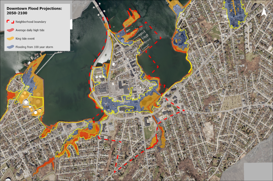
The city of South Portland is among the first communities in southern Maine to create detailed maps that show what flooding due to sea level rise will look like in the coming decades.
The maps use state sea level rise data, but reveal in more detail down to individual streets and properties, what will be impacted with a projected 3.9 feet of sea level rise.
They show that seven neighborhoods will be particularly vulnerable to flooding during three broad scenarios — daily high tides, the occasional astronomical, or "king" tide, and major storms — within the next 25 to 75 years.
"Those three scenarios, on top of sea level rise, give us a pretty accurate understanding of the range of potential coastal flooding in the future," South Portland community planner Laura Berry said. "And that's what we're trying to share with folks."
While most residents look for their own homes on the maps, regional officials are urging them to think more broadly.
"People can understand the road they drive on to get to the grocery store, the grocery store they go to, the services, the schools where their kids are — they can really see what that might look like in 25, 50, 75 years," said Sara Mills-Knapp, director of sustainability for the Greater Portland Council of Governments, which collaborated with South Portland in developing these new maps.
The city and GPCOG hosted an event Tuesday to introduce the maps to the public and solicit questions and feedback.
The maps show that several major routes connecting the downtown South Portland peninsula to the Casco Bay Bridge will be inaccessible during future king tide events and major storms.

A nearby electrical substation will be completely inundated. And major storms are expected to impact the city's wastewater treatment facilities.
Elsewhere in South Portland's Breakwater neighborhood, projections show that Bug Light Park and Southern Maine Community College face threats of flooding, particularly during major storms.
Bug Light Park may be inaccessible during future king tides. The entire Breakwater peninsula could have up to three feet of inundation during major storms, particularly if they hit during high tide.
Floodwaters will be at their highest during 100-year storms, events with a 1% chance of occurring annually, or a 26% chance over the course of a traditional 30-year mortgage.
"The footprint, the area footprint, is not going to be very different between a 10-year storm and a 100-year storm," said Julie Rosenbach, sustainability director for the city of South Portland. "But the depths will be different."

In some neighborhoods, city officials have estimated how many residential properties will experience flooding under these scenarios. In Willard Beach, for example, projections show 62 residences with a combined assessed value of $118 million during major storms. More than 20 properties in the neighborhood are expected to experience "sunny day" nuisance floods during king tides.
Throughout South Portland, city planners have identified several petroleum storage tanks that could be vulnerable under different flood scenarios. In the Ligonia neighborhood, for example, water is expected to overtop the protective seawalls and rip-rap surrounding petroleum storage tanks during king tides and major storms.
The mapping project is part of South Portland's comprehensive planning update, but Berry said it's taken on additional urgency in the wake of the January storms.
Starting next month, the city will host meetings with residents to begin prioritizing parts of the waterfront to protect and adapt.
Mills-Knapp said other communities in southern Maine are interested in creating their own sea level rise and flood maps.
The new South Portland maps can be found here.


