
Live updates: Vermonters can start applying for FEMA aid


By the end of Vermont's flooded week, communities were busy with cleanup — with a watchful eye on more rain in the forecast. Find the latest updates from Vermont Public below.
For photos and updates from Monday and Tuesday, see our previous liveblog here.
Flood safety and other key resources
- For state road closure information, visit newengland511.org or follow @511VT on X. (For local road closures, use the Waze app or monitor town communications, such as a website or Facebook page.)
- You can sign up for alerts from the state at vtalert.gov.
- The latest forecasts and water levels for specific rivers are provided by the National Water Prediction Service.
- Find power outage information at vtoutages.org.
- To find more resources and services, and to report flood damage, call Vermont 2-1-1 or visit vermont211.org.
- For a list of state resources and guidance about flooding, visit vermont.gov/flood. The guidance includes returning home after a flood, cleaning up, and dealing with mold.
- Find flood recovery information in multiple languages at vem.vermont.gov/flood/translation.
- To request cleanup help from volunteers and groups, call the Crisis Cleanup hotline at 802-242-2054.
- For mental health support, call 9-8-8 or call or text the SAMHSA Disaster Distress Helpline at 1-800-985-5990.
- To register through the state to volunteer, visit vermont.gov/volunteer.
- If flood waters reached your private well or spring, order a drinking water test kit through the Vermont Department of Health.
- Find flood-prone areas near you with the Vermont Flood Ready Atlas.
Meals, water, supplies and guidance offered together in Barre and Ludlow, more locations to come
Vermonters will be able to find many types of help in a single location this weekend in Barre and Ludlow, according to Vermont Emergency Management.
According to a press release, here's what the locations will offer:
- Meals and water from the Red Cross
- Cleaning kits
- Answers to questions about recovery resources
- Mental health services
- Basic medical services
The first locations of these multi-agency resource centers, or MARCs, are below:
- Ludlow: Community Center, 37 Main St.
- Barre: BOR Arena/Barre Auditorium, 16 Auditorium Hill
The Ludlow and Barre centers will be open 9 a.m. to 5 p.m. July 15-17.
Federal workers record Vermont's high-water marks

Hydrologists from the U.S. Geological Survey have arrived in Vermont to quantify the severity of the flooding earlier this week.
Seven crews deployed to the state Wednesday and will remain through next week to record high-water marks in hundreds of spots around the Winooski, Lamoille, Otter Creek and other rivers.
Gardner Bent, a USGS hydrologist, said the federal agency is collecting the data on behalf of the Federal Emergency Management Agency.
“FEMA creates these flood insurance rate maps — it’s used for that. It’s used for flood inundation models,” Bent said. “And it’s also used to calibrate other hydraulic models that we do when we’re developing these flood insurance rate maps.”

Bent said sometimes high-water marks are still visible on the walls of buildings. Other times, he said, it takes some detective work.
“Other places we’re in the woods, and we’re looking at things that might get caught in bark or a mud line,” he said. “At the last location we were at it was a mud line on a door of a building, and so we can use that - that’s how high we know that the water got.”
Montpelier closes downtown streets to traffic

To keep roads open for emergency response teams and cleanup volunteers, the city of Montpelier is shutting down portions of its roads to other traffic until further notice.
The city announced these closures on Friday, effective immediately:
- Main Street closed from Barre Street to School Street
- State Street closed from Main Street to Taylor Street
- Elm Street closed from State Street to School Street
Biden approves major disaster declaration

Individuals affected by floods in Vermont can now apply for financial assistance from the federal government after President Joe Biden approved Gov. Phil Scott's major disaster declaration on Friday morning.
People have 30 days to apply for assistance for housing repair, rental assistance and personal property loss, a Federal Emergency Management Agency representative said at the governor's press conference on Friday.
Individuals in these counties are currently eligible:
- Chittenden County
- Lamoille County
- Rutland County
- Washington County
- Windham County
- Windsor County
Residents and business owners can call 1-800-621-3362 or visit disasterassistance.gov to start the process. Amounts and programs will depend on each person's need and circumstances.
The major disaster declaration also allows Vermont towns, nonprofits and the state to be reimbursed for "emergency protective measures" in all 14 counties.
Other key takeaways from the press conference:
- Last night's storms were not as bad as feared, but Bridport, Shoreham, Cornwall and Middlebury were hit hard, said Public Safety Commissioner Jennifer Morrison. There was also some road damage in other parts of the state.
- Drinking water safety: If you're on a municipal water system, follow any boil water and do not drink orders. If you use a well or spring for your drinking water, and you're in a flooded area, assume the water is contaminated and don't drink it or use it for food or drink preparation until you get it tested, said Health Commissioner Mark Levine. The state health department is offering free drinking water test kits for people impacted by flooding: call 802-338-4724.
- Mental health: People who are struggling after the floods can call or text the national Disaster Distress Helpline (1-800-985-5990) to speak with a counselor.
- Amtrak returns: Railway reopening will allow Amtrak to get back into Burlington tonight and resume southbound passenger service on Saturday morning, said Transportation Secretary Joe Flynn.
- State-local communication: National Guard troops will go Friday to "two to three dozen communities" that have not been in touch with state officials to establish contact and start finding out about local needs, Morrison said.
- Road closures: 19 state roads remained fully closed and nine were partially closed as of Friday morning. Flynn said much progress had been made in the last couple of days.
- U.S. Transportation Secretary Pete Buttigieg plans to come to Vermont on Monday.
View and share printable flood recovery resources
Vermont Public has collected a list of resources on flood safety and recovery in a printable PDF flyer. Readers are encouraged to print and share this document with neighbors and community organizations, especially in cases where power or internet access may be limited.
This guide includes safety tips for experiencing or anticipating flooding, guidelines for returning to flooded property, help avoiding scams, resources for farmers, and opportunities to help or volunteer.
Storms bring power outages Thursday night but no major flooding reported
Thunderstorms that rolled through the state Thursday afternoon and evening don't appear to have caused significant flooding — a relief for communities across Vermont reeling from devastating floods earlier this week.
The storm Thursday night did cause power outages; nearly 18,000 homes were without power at one point. Rutland County was hit the hardest, and the Upper Valley saw a lot out outages too. As of 7:10 a.m. Friday morning there were 3,967 customers without power with nearly half of those outages in Rutland County.
While the storms on Thursday weren't expected to be as severe as the one earlier this week, Gov. Phil Scott issued a stark warning to Vermonters and advised residents to get off the roads, stay home, and prepare for more rain in the coming days.
"It's critical that Vermonters understand that we need to remain vigilant and prepared — do not be complacent, " Scott said during a press briefing on Thursday.
More rain is in the forecast for Friday and over the weekend. The National Weather Service says showers and thunderstorms are on deck for Friday afternoon — under an inch in most places — with the heaviest rainfall expected in southern and eastern Vermont.
The National Weather Service in Burlington on Friday morning issued a flood warning for Otter Creek At Middlebury affecting Addison County. The river is expected to rise above flood stage this morning and continue rising to a crest of 7.8 feet just after midnight tonight. Minor flooding is forecast in parts of Rutland and Middlebury.
Early forecasts for this weekend show a few more inches of rainfall are expected on Sunday.
Thunderstorms roll into Vermont, forecast contains more rain
After a stretch of relatively calm weather, severe thunderstorms are rolling into Vermont this evening.
Public safety officials are warning residents that heavy rains could lead to more flash flooding — especially in areas that have already been pounded with water.
To get the latest on tonight’s weather outlook, Vermont Public’s Mary Williams Engisch spoke with Greg Carbin. He’s chief of forecast operations for the National Weather Service Weather Prediction Center in College Park, Maryland.
Mary Williams Engisch: To start off, how much rain can we expect tonight? And where has the Weather Service instituted some flood watches?
Greg Carbin: Right, so the whole area is under a flood watch. And we're starting to see some severe thunderstorms move across the Champlain Valley. And we'll continue to see that through the evening hours. Some of the storms could contain pretty gusty winds. So one of the concerns is with the wet ground — it's not going to take a lot for trees to come down.
Rainfall amounts, probably in the range of 1 to 1.5 inches in most places. Locally, a little worrisome, especially across southwest Vermont. Rainfall amounts could be up around 2 to 2.5 inches.
And it doesn't take much at this point. Is that correct? If it was a normal July, this wouldn't be such a big amount of rain. But currently that sort of rain could cause some more flooding. Is that right?
Right. I was just thinking along the same lines. You know, a normal July, this would be a thunderstorm passing through with a pretty good downpour, maybe some localized set of runoff issues. But given that the ground is saturated, there's nowhere for this water to go, other than to raise up the creeks and rivers again.
Now, this is not the event that we saw the other day; this will be a quick shot of some pretty heavy rain over an hour or two. But there's still vulnerable locations out there, as we just heard.
And Greg, I was just reading from Environment Canada, a tornado warning was rolling through from some heavy storms there. Is that also a small chance for us here as well?
Yeah, I think it's a chance, but it is smaller than they were looking at earlier today in Ontario; that was associated with the actual low pressure system. And there was a lot of spin in the atmosphere there. That system is now moving up into southwest Quebec. There's also a chance of an isolated spin up tornado, but these storms are primarily going to bring gusts of wind and torrential rain for an hour or two.
It's sort of hard to pick our head up and look toward tomorrow, even at this point weather-wise. But I understand we could also see rain tomorrow. How does the two-day stretch compare to the amount of rain that we saw in Vermont earlier in the week?
It'll be far less there. It is unfortunate, the general pattern seems to support almost daily shower and thunderstorm activity, not quite as organized tomorrow as what we're seeing this evening. But then again, I do believe there could be some concern as we move into the weekend, especially Sunday. Looks like another potential day for some heavy downpours. So we're definitely not out of this pattern yet. And it's really quite persistent and bothersome.
And you touched on this just a moment ago, Greg, but I think it's really worth sort of breaking it down even further. Officials are repeatedly warning Vermonters to stay vigilant for more flooding, more flash flooding, even though we're not getting as much rain as we did earlier this week. Can you just sort of explain for us even further why this current forecast of rain is such a potential issue for more flooding?
Yeah, well, again, we're not looking at what we saw on Monday by any means. This is kind of a quick shot; Monday was an extended period of very heavy rain. So this is a little bit different. But the ground is saturated. And we know we have deep, deep valleys. And with the ground saturated, there's nowhere for the water to go — it will run off very quickly. And you know where you live; you know where those vulnerable spots are along the creeks and riverbed. So just be aware that you could see some rapid rises — especially in the presence of heavy rainfall this evening.
Greg, you're based outside of Washington, D.C., but you're from the Barnard-Woodstock area, and you have some family around Vermont. And when we spoke on Monday, you mentioned some flooding that you'd observed over the weekend when you were in town. How has it felt seeing everything that's happening in Vermont this week, especially as someone who's so tuned in to these weather patterns?
It feels like we're more vulnerable than I thought we were. That's the honest truth. But I always thought Vermont was a relatively safe place. I grew up there and fell in love with meteorology there because of the snowstorms in the winter mostly. But the summer thunderstorms were often fun to watch, but they're not so much fun when you're dealing with widespread destruction like we saw this past week. And it seems like we've taken on a role that we've seen in other parts of the country where there's a lot of vulnerability. That, you know, is certainly unwelcome. And it just feels that we've entered this time with more active weather. And we just gotta keep keep dealing with that.
Yeah, break down a little bit more that term you're using: vulnerability. Is that due to weather patterns changing? Is that due to different infrastructure? Or is it just a combination that you're seeing?
Well, I think it's both. I think there’s demographic underlying vulnerabilities in the way that we've built our environment to try to handle, say, a 100-year flood that maybe occurs every few decades. And we're seeing these events increase, the frequency of these events increase across the country — around the world. And Vermont is not immune from that. And so we need to take that into account as we recover from this event, and face future events.
More from Vermont Public: The connection between extreme rain and climate change in Vermont
Well, lastly, Greg, we're expecting more severe weather in the near future. Can you look for us toward Sunday and describe that forecast?
It looks like we see these episodic events now with these upper-level disturbances coming out of Canada. Basically, the pattern is one in which you see very, very hot, dry conditions across the Western U.S. But to the east of that hot ridge of high pressure in the West, you have northwest flow, the jetstream, bringing in these disturbances out of Canada, capping warm, moist air just to our south and resulting in daytime showers and thunderstorms. And we don't need any more of this. But unfortunately, the pattern looks quite persistent, at least through the weekend, perhaps even into next week. And it's just just not changing anytime soon.
What to know about getting rid of garbage after a flood

Vermonters are dealing with a lot more garbage than normal as they clean up flooded basements, shops and homes.
You're eager to get rid of it all — but more important than speed is safety, state officials and solid waste workers say.
Here are some tips for disposing of damaged items and flood debris.
Do you see oil in your basement?
If you have any fuel tanks in your basement, be extra cautious about flood water. Stop and check if there is any oil or petroleum floating on the top of the water.
If you see oil, it needs to be pumped out by a professional — from the top.
"If you pump from the bottom, you will coat your basement in oil and create a much more expensive cleanup for you and your household," Kelly said.
Call the Vermont Department of Environmental Conservation at 800-641-5005 (24/7) or 802-828-1138 (during the workday).
The state can help find a contractor for the pump-out.
More from Vermont Public: What to know about returning home after a flood
These items need to be kept separate
Do everything you can to keep hazardous, toxic and banned materials out of the normal waste stream, says the Department of Environmental Conservation.
That includes things you might find in a flooded basement:
- Paint, varnish, and paint thinners and strippers
- Gasoline and oil
- Pool chemicals
- Appliances like freezers, refrigerators and air conditioners
- Tires
- Electronics
- Fluorescent bulbs, thermostats and thermometers that contain mercury
- Batteries
These items need special handling. In some cases, you can bring them to your local transfer station; in other cases, you may need to keep them safe in a stable location until you have a chance to dispose of them properly.
"Separate the most toxic stuff from your trash, so that you're not endangering solid waste workers by throwing chemicals into a roll-off dumpster that can mix and cause fires or cause injuries, or they can create really a hazard to the environment if they leach," said Josh Kelly, solid waste program manager in the Department of Environmental Conservation, Waste Management and Prevention Division.
Contact your solid waste district or hauler if you have questions about any particular item.

What to do with hazardous waste
Some transfer stations are able to accept hazardous waste, and some will ask you to wait. In hard-hit Londonderry, for example, the outgoing voicemail message on Wednesday told residents that hazardous waste collection would happen at a later date.
"If you need to, you can keep them in a separate part of your yard. You don't want them to be leaking. You don't want them to migrate to your own soil," Kelly said. "But it's important that they get collected separately from waste."

What to do with appliances
You may have air conditioners, refrigerators and freezers that have been damaged in the flood. All of these are banned from the landfill.
"They're collected at transfer stations around the state as well as scrap yards — they have value, but they have refrigerants that need to be safely drained," Kelly said. "If they are chucked into a dumpster, they can break and those refrigerants contribute to climate change."
Set these bulky appliances aside, and bring them to a scrap metal yard or a transfer station — or hire a contractor or hauler to bring them for you.
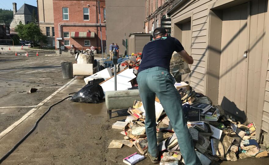
How to get a dumpster
If you have a large amount of waste, or many bulky items, check what your town is offering. Some towns, such as Waterbury, have obtained dumpsters for residents at no cost. Others, like Montpelier, are offering special curbside collection for things like waterlogged furniture or boxes of books, Kelly said.
Otherwise, contact a hauler to rent a roll-off dumpster — or call your hauler and let them know you have a large amount of trash, and see what they can do.
And try to be patient.
"As people call for dumpsters, they may start to find that haulers are running out of them. I haven't heard that yet," Kelly said. "But I anticipate as everybody starts to clean up, it may be a while before they can have a service."
Dealing with mold
Wear gloves and a mask while dealing with items that may be moldy. Keep children and pets away while cleaning up.
To protect haulers, it's best to bag moldy items before placing them in the trash, said Jeff Weld, director of engagement for Casella.

Compost and recycling
Vermont normally requires people to separate food scraps and recyclables from the waste stream. But that isn't the case when those items have touched the flood mess. Wet, contaminated paper is not recyclable, Kelly said.
Any food or recyclables that have been in contact with floodwaters can be disposed of in the same bag, said Sarah Lillibridge, the outreach coordinator with the Lamoille Regional Solid Waste Management District.
Does Vermont have enough waste system capacity for this storm?
Casella reports that the sole landfill in Coventry has sufficient capacity for an influx of flood debris, and it's open and operating as usual.
Casella is bringing in extra dumpsters, trucks and personnel from other states to respond to the flood damage, using a response model that was developed for the COVID-19 pandemic, Weld said.
Many haulers and transfer stations are operating as usual, or with increased hours. Check local websites for the status.
In Montpelier, the residential transfer station operated by Casella was flooded in the storm and is temporarily closed. The central Vermont transfer station in East Montpelier is an alternative.
Officials hopeful Wrightsville Dam spillway will not overflow in coming days

State officials say they are hopeful that additional rain over the next few days will not result in the release of water from the spillway of the Wrightsville Dam just outside of Montpelier.
During the torrential rainfall earlier this week, the water level at the dam was within a foot of its spillway.
The actual top of the dam is another 30 feet higher.
Maggie Gendron is the deputy secretary for the Agency of Natural Resources.
She says her agency has studied this issue and she doesn't believe the spillway will overflow at this time.
"Right now this is an important message for you to take away, please — right now, based on the current forecasted weather and the modeling, it is unlikely that we will have water flow over the spillway at rest at Wrightsville, and this has not occurred to date," she said.
Gendron says a release of water through the spillway will not necessarily cause major flooding because the water level of the nearby Winooski River has fallen several feet in the last few days.
Governor urges Vermonters to prepare for more flooding
Gov. Phil Scott is urging Vermonters to be prepared for additional flooding over the next few days.
Over the next 48 hours, thunderstorms that could cause flash flooding are expected.
Speaking at a press conference today, Scott said he's also concerned about extended rainfall forecast in most parts of Vermont for Sunday.
"I know this is hard news for many. And folks will want to think this is over as soon as the weather breaks on Saturday," Scott said. "But it's critical that Vermonters understand that we need to remain vigilant and prepared. Do not be complacent."
State officials say they do not expect the flooding over the weekend to be nearly as extensive as conditions were earlier this week.
Scott requests additional federal disaster relief funds
The Scott administration is asking for additional disaster recovery support from the federal government.
The governor requested a major disaster declaration with the Biden administration this afternoon Thursday.

The request comes after the head of the Federal Emergency Management toured damaged homes and businesses in Montpelier and Barre Wednesday afternoon.
"If approved, would provide federal disaster relief funds which will be very helpful to communities in the recovery phase," Scott said. "The disaster declaration is one of the reasons it was important to have the administrator and members of her team here yesterday to see the enormous needs we have as we move forward."
FEMA officials are encouraging Vermonters to begin their recovery efforts as soon as possible and to take photos to document their work for later reimbursement.
First flood-related death reported
The Vermont Health Department has confirmed the first death related to this week's storms and flooding.
A Barre City man, 63, died as a result of a drowning accident in his home Wednesday, according to a news release.
The state Office of the Chief Medical Examiner investigated the accident, along with the Barre City Police Department.
Public officials are urging Vermonters to take caution as more storms sweep the region today and this weekend. You can find health and safety guidance at Vermont Emergency Management's website.
Check for structural damage before entering a flooded building

Many displaced Vermonters are thinking about returning to their homes in the coming days.
Keeping an eye out for possible dangers in recently flooded property is crucial.
Will Moran of the Vermont Health Department says evacuees should assess their homes from the outside before entering, because moving water can be incredibly powerful.
“Moving water is incredibly powerful, and if that water pushes against the home, it can dislodge structural components,” Moran said. “So when you walk up to your home, you know, make sure you're looking for things like walls that are leaning in, cracks in the foundation, maybe a sagging roof.”
If you see signs that your home might be structurally damaged, Moran not entering, and instead calling a professional.
For those who can re-enter their homes, he recommends wearing protective clothes gear, like a mask.
More from Vermont Public: What to know about returning home after a flood
Which areas in Vermont were hit the hardest?
The storm that devastated Vermont moved slowly over the state on July 9-10, dropping high levels of rain on soils that were already quite wet. Flash flooding swept through some communities.
Next, rivers overfilled their banks, spilling into additional areas.

In the central part of the state, North Calais led the rainfall totals with 9.2 inches, according to the National Weather Service, and Barre saw a whopping 7.8 inches of rain in the storm. Vermont's capital, Montpelier, watched as the Winooski River swelled and poured into downtown Monday evening.
Plymouth in Windsor County also ranked high in rainfall, with a member of the public measuring just over 9 inches of rain.
In the southern part of the state, Weston recorded 6.8 inches of rain. The town and its neighbors, Ludlow, Londonderry and Andover, were considered by state officials to be among the hardest-hit communities as of Tuesday.
On Wednesday, state officials pointed out Lamoille County as a focus, with swift water rescues ongoing in Jeffersonville in the town of Cambridge.

Rivers across Vermont responded differently to the heavy rains.
"It's very variable because depending on how the river is oriented, how the catchment of the river basin is oriented in the terrain, different amounts of rain can lead to different river levels," said John Goff, a senior service hydrologist with the National Weather Service's Burlington office, in an interview. "You could put the same amount of rain in two different river basins, and they would rise at different rates."
According to the National Weather Service, rivers reached major flood stage at some point this week in Jeffersonville and Johnson (also indicating flooding in Hardwick and Morrisville), Montpelier (also indicating flooding in Waterbury), Rutland, Essex Junction (indicating flooding in downtown Richmond, the Intervale in Burlington, and other local areas), Rockingham and Northfield Falls. Levels of damage varied.
Wastewater line break sends sewage into the Winooski River, Lake Champlain

Burlington Department of Public Works say a sewage pipe beneath the Winooski River broke early yesterday morning, sending untreated wastewater into the river and Lake Champlain downstream.
According to a press release, the break was discovered around 6 a.m. Wednesday.
Officials said crews were quickly mobilized to respond, and the state was notified. Crews were able to block off the sewer crossing pipe to ensure that the majority of the wastewater goes to the treatment plant, according to DPW.
As of yesterday, 10% of the city’s untreated wastewater was still entering the river.
DPW says because of the huge volume of water in the river, the sewage will be diluted. Still, officials are cautioning against swimming at beaches near the lake's north shore — from Starr Farm Dog Park and northward.
National Weather Service issues flood watch for Thursday

The National Weather Service is warning some parts of central and northern Vermont, and the western edge of Franklin and Chittenden counties could experience flash flooding today.
A flood watch is in effect from 2 p.m. through late tonight.
Between 1-2 inches of rain is forecast to fall this afternoon and into the evening.
Today's storms could be severe, bringing large hail, damaging winds and heavy rain. With rivers, creeks, and streams already running high, flash flooding is a possibility.
NWS says flash flooding is possible in Essex and Clinton counties in New York as well as portions of Vermont, including: Caledonia, Eastern Addison, Eastern Chittenden, Eastern Franklin, Eastern Rutland, Eastern Windsor, Essex, Lamoille, Orange, Orleans, Washington, Western Addison, Western Rutland and Western Windsor.
Scattered to numerous showers and thunderstorms are expected this afternoon and evening. Some t-storms will be severe with damaging winds, large hail, and locally heavy rainfall. Please ensure you have a way to receive our warnings today and keep an eye on the sky! #NYwx #VTwx pic.twitter.com/SGUb4AbiFX
— NWS Burlington (@NWSBurlington) July 13, 2023
You can sign up for warnings through VT Alert .
State and federal officials view flood impacts firsthand in Barre
Gov. Phil Scott toured a Barre neighborhood this afternoon that suffered extensive damage because of the intense flooding earlier this week.
Many homes still had basements full of water and as a result had lost all electricity.
Scott said he wanted the residents to know that the state is prepared to help them recover in any way that it can.
"This my hometown of Barre, and I see that people are struggling," Scott said. "They were struggling before, trying to get by. And this just puts more burden on them. So my heart goes out to them. But I want them to know we're we're here for them. And we're going to help them through this and together."
Also touring the damage were FEMA Administrator Deanne Criswell and the three members of Vermont's congressional delegation.
"I've never seen anything quite like this," said Sen. Bernie Sanders.
Sanders vowed to assist residents in securing federal aid and dealing with private insurers. "What we're going to have to do is coordinate federal agencies and try to make sure we get the help to people who need it as quickly as possible," he said.
State agriculture agency provides resources to farmers impacted by floods

The Vermont Agency of Agriculture has released a resource page for farmers beginning to assess the damage from this week's floods.
It provides instructions for what farmers can do about crop losses, if they have to dump milk because trucks can't get to their road, and where they can go for emergency funds.
While the state hasn't yet provided any preliminary damage estimates to Vermont's farms, the Northeast Organic Farming Association of Vermont said in a press release Wednesday that more than 40 farms have reported being impacted by this week's severe flooding.
NOFA-VT said those impacts range from isolated losses of fields and/or equipment to "complete devastation."
The organization noted many farms are still in the early stages of assessing damage, after floodwaters began to recede last night.
More rain on the way? What to know about the forecast.
After days of heavy rains that washed out roads and flooded cities and towns across our region, the skies have been looking a lot clearer.
But just as Vermonters are beginning to assess the damage from the recent flooding and high waters, many are now bracing for more rainfall this Thursday and Friday.
John Goff is a senior service hydrologist with the National Weather Service's Burlington office. Vermont Public’s Mary Engisch spoke with Goff to take a closer look at what weather Vermonters might be dealing with in the next couple of days. Their interview is below and has been edited and condensed for clarity.
Mary Engisch: The National Weather Service put out some final numbers for the rainfall totals from Sunday to Tuesday. Can you break down the big takeaways from that data?
John Goff: In general, along the spine of the Green Mountains, we generally saw about 5 to 8 inches of rain, 4 to 8 inches of rain, with localized totals to 10 inches. As you get away from the spine of the Greens toward the Connecticut and the Champlain valleys, those amounts were in general a little bit less, more like 1 to 3 inches. There are some comparisons to Irene and the rainfall distribution during Irene, but there are a lot of differences as well.
Without further ado, we have our final rainfall map for a historic two-day rainstorm.
— NWS Burlington (@NWSBurlington) July 11, 2023
The greatest storm total was 9.2", with many 6-9" amounts along and just east of the Green Mountains. pic.twitter.com/iahi7oGKIf
What's the forecast for the next few days for Vermont?
Our forecast, as you mentioned, is calling for a new threat of showers and some thunderstorms across the area, especially tomorrow into tomorrow evening. Given the recent terrible flooding we've seen across the state, our hearts go out to a lot of people that have been impacted by this terrible event.
We're not expecting the rainfall nearly the same magnitude that we just saw a couple days ago. However, due to an abundance of caution, we are in a heightened state of awareness from a public safety and warning standpoint. So given the rainfall that is coming in, we probably will end up having another flood watch out for portions of the state tomorrow into tomorrow evening. [Editor's note: After this interview, the National Weather Service did issue a flood watch for most of northern and central Vermont from Thursday afternoon through evening.]
The overall rainfall amounts generally are about ¾ of an inch to an inch and a half. That was typical with any type of event, there'll be variability in there. So some people may unfortunately see a little bit more than that. Other people will see less.
Floodwaters continue to recede today under generally dry conditions. Unfortunately, several rounds of showers and thunderstorms are expected Thursday through Friday with additional rainfall in excess of 1" possible. This will renew the threat for additional flooding. pic.twitter.com/QnBmzN706m
— NWS Burlington (@NWSBurlington) July 12, 2023
Public safety officials are warning Vermonters that the upcoming rain might be problematic because the soil across the state is already so saturated with water. Break down how that would work when there's so much water in the soil, in the ground and in the rivers. And it's going to rain even more.
Normally, when you have a heavy rainfall, there's a couple of factors that go involved. One is called the infiltration rate. It's how fast the water can be soaked up into the soil or absorbed. The other we look at closely is the rainfall rates themselves: how hard is it coming, how short a period of time. For example, if I get an inch of rainfall and that happens over a day, day and a half, the soil has the capacity to absorb that and allow that water to run off into the creeks and streams gradually. If I get that inch and a half an hour, that capacity is overwhelmed, and a lot of that runs off. So those are the things we look at closely.
Right now, a lot of the soils are extremely moist. I wouldn't say completely saturated at this point; there's always a little bit of absorption capacity that we can have. But given the recent rains, there's not a lot of wiggle room with how much they can absorb. So if we have a thunderstorm sitting over Montpelier or Barre tomorrow evening, and then it puts down an inch or an inch and a half of rain in 45 minutes, we're going to have some issues with the current state of the soils. If you get heavy rainfall in a short period of time, a lot of that is going to freely run right off into the streams and creeks, and that's what we're concerned about.

This amount of rain is not common. Can you break down what caused this recent storm to be as extreme as it was?
An event of this magnitude is not common. In terms of the general climatology of when heaviest rains or precipitation falls, yes, July and August are those heavier months. In general, it's the warmest time of year, and warmer air in general has a higher capacity to hold moisture in the atmosphere. So your probabilities of getting heavy rainfall are just naturally higher.
In addition to the rain this weekend, it will also be really warm. A lot of people want to go jump in their favorite swimming hole. Is it safe to go in? I know the river levels across the state are really quite high and probably will remain so.
Yeah, not a good idea to take a swim or do a kayak trip down a river right now. We will probably be putting out some public safety messaging from our standpoint just to keep people away. And certainly in higher hazard places where drownings have occurred in the past — the Bolton Potholes, the Huntington Gorge, for example. Those are extremely dangerous right now. I would stay away from some of that.
In terms of what people can do if they want to take a dip. I would more frequently recommend them doing that in a lake as opposed to an area of moving waters.
John, when it comes to rain amounts, we hear a lot about how many inches some parts of the state got — comparing that to how we talk about certain dams reaching their capacities, those water amounts often measured in feet and not inches. Can you help our listeners and me do the math here?
There's a rough correlation, but it's very variable. You have to understand that dams are there generally for two reasons: for hydroelectric power production and for public safety. In terms of rivers, it's very variable because depending on how the river is oriented, how the catchment of the river, the river basin is oriented in the terrain, different amounts of rain can lead to different river levels. You could put the same amount of rain in two different river basins, and they would rise at different rates.

In terms of behind the reservoirs? Yeah, we're seeing some phenomenal rises. But those reservoirs are generally safe. They're designed for flood safety. So for example, if you look at the North Hartland dam, that's just above Springfield, and North Hartland there, that was designed years and years ago for flood safety going into the Connecticut River. So while the river and the reservoir came up about 80 to 90 feet behind the dam, that's actually a good thing, because it's holding back water from the Connecticut that would otherwise freely flow into the river and flood things really bad downstream.
And lastly, John, are there any other takeaways that you want to share with Vermonters about the upcoming weather forecast?
Yeah, I would just say be very vigilant, especially if you're in areas that were affected by flooding already. Of course, a lot of these people, unfortunately, are cleaning up. Our heart goes out to those people.
Know where your trusted sources of information are: whether that's a media channel, a local or state official, whether that's from us. Know where your sources of information are to get the latest warnings, to help you make your best decisions and have a plan to know what to do, when and where to go.
Vermonters should avoid swimming in rivers, streams

After this week’s historic flooding, first responders urge Vermonters to avoid swimming in rivers and streams.
Sarah Lamb is a paramedic at Richmond Rescue, and says staying alert near water is incredibly important.
“Take a minute and see what's upstream and downstream, and make sure that there's not like a big rapid, because it could be really beautiful and placid in one spot, and then just down around the corner be incredibly deadly," Lamb said.
Lamb says if Vermonters want to cool off this week after the heavy rains, they could do so at a reservoir or pond.
Vermont National Guard responds to flooding
Members of the Vermont National Guard's Quick Response Force are stationed in Berlin and Colchester to assist with flood rescues and recovery.
Commander Matthew Tatro said members of the Guard's Quick Response Force teamed up with a swift water rescue team in Cambridge yesterday.

Once there, they used the Guard's high-axle vehicles to move through high waters, relocating nearly 30 people and some pets in the process.
"And so we moved them in past some water to a point with their boats," Tatro said. "They then went and ferried the people, brought them back to the truck, the truck then brought them off to a dry or safer spot. "
Tatro said Guard members are activated depending on weather patterns analyzed by the State Emergency Operation Center.
Members will remain activated until further notice to assist in cleanup statewide.
Sorrow and lots of mud in Cambridge


Cambridge in Lamoille County saw dangerous flooding Tuesday and overnight as the Lamoille River spilled over its banks.
Corn fields and several major roads were still inundated by mid-afternoon Wednesday.

On Main Street, 8 to 10 feet of water filled the basement apartment below Glitz Hair Design.
Stephanie Roberts, who has owned the salon for 16 years, was on site with neighbors pulling out mud-covered appliances.
"Looking at the salon, you know, if you were to walk in you wouldn't think that there was a problem — but you know, we have to keep in mind all the stuff underneath us," Roberts said. "You know, we'll have to redo electric, fuel tank, hot water tank."

With all the work required, Roberts said she's not sure when the salon can reopen.
"Just take one day at a time, I guess," she said.
Most of the houses in Cambridge village were flooded. Some had four or more feet of water on their first floors. Residents are helping each other pump out their homes with generators.
At the Family Table restaurant, chef/owner John Raphael described a difficult journey kayaking from his home in Belvidere the previous day.
"I underestimated the current and hit a tree, then spun around, hit a pole, then capsized," Raphael said. "And then yeah, it was quite an adventure. But I made it over here to see what was going on."
On Wednesday he said the feeling in town was sorrow. The first floor of the restaurant was OK, but he was taking stock of damage in a flooded basement, including systems like hot water and a computer.
"Need that stuff," Raphael said. "Need the AC — no one wants to sweat in their soup."
How to avoid disaster relief scams
The consensus across the state of Vermont this week following devastating flooding is that people want to help. Doing so safely is everyone's number one priority.
Unfortunately, in times of natural disasters, scamming can happen at higher rates.
Attorney General Charity Clark says this is because of the "magical formula" it creates, where your emotional response is easily triggered, especially if a stranger is asking you for money or help, and it seems urgent.
A common scam during natural disasters uses fake contractors assessing damages. These scams can be devastating to people already dealing with the damage.
Clark says that as of this year, all home improvement contractors have to register with the Secretary of State's Office, so you can look up home improvement contractors and see if they're listed and what work they've done. Additionally, the Attorney General's Office has a list of contractors convicted of fraud.
For phone or email scams relating to disaster recovery, Clark says the safest way to know that someone who is calling you is really trying to help is to do your own research. Going to a trusted website and finding a phone number or email address independently is better than assuming the random call is trustworthy. She also reminds people to not click links in emails if you can't confirm the sender.
See drone footage of flooding in Montpelier, Barre, Middlesex, Londonderry and Chester
Vermont Public's Kyle Ambusk captured aerial footage of some hard-hit communities around the state on Monday and Tuesday. See the view from above Montpelier, Barre, Middlesex, Londonderry and Chester.
Vermont officials on volunteering options, 'regulatory relief' and trauma
At a press briefing Wednesday, state officials noted Vermont's government is NOT organizing donations of physical items.
If you want to help, sign up at vermont.gov/volunteer and await instructions. Public Safety Commissioner Jennifer Morrison also encouraged people to donate to the Northern New England Red Cross or their local United Way.
In the aftermath of this week's flooding, U.S. Rep. Becca Balint asked Vermonters to be gentle with their neighbors.
"This is a difficult time for so many, for families, for individuals, for small businesses, and also for farmers," Balint said.

And to help expedite the state's rebuilding process, Gov. Phil Scott announced today he would sign an executive order to lift regulations.
More information is expected to come on this.
Vermonters don't need to wait for FEMA to begin cleanup
FEMA Administrator Deanne Criswell, who traveled to Vermont to survey the damage, said during a press briefing today that people do not need to wait for a FEMA inspection before starting to remove debris from their homes.
"Take pictures, document your damage, gather your important papers, contact your insurance company, have all of that information available," Criswell said. "But you do not need to wait to start the cleanup process. The faster you can get that moved out and the debris removed out of your home, the easier it's going to be for the recovery time."

In the meantime, Sen. Peter Welch said all three members of the federal Congressional delegation are focused on making sure insurance processes are effective.
"We're going to work with them to make sure that they are not nickel and diming people, but are responding to the real damage that people are seeing," he said.
State officials say rescues, flood concerns are ongoing
Vermont's first responders are still rescuing people from flood water today, and state officials are urging Vermonters not to let down their guard.
"We are still in active response mode and have multiple rescues ongoing. The hardest-hit area currently is Lamoille County, where we rescued 32 people and numerous rescues overnight," said Public Safety Commissioner Jennifer Morrison at a press briefing this morning.

She says there continue to be flooding concerns at the following locations:
- Winooski River at Essex
- Lamoille River at Jeffersonville
- Missisquoi River at East Berkshire
- Otter Creek at Center Rutland
- Arrowhead Dam in Milton
"Regardless of river levels, our waterways are not safe right now," Morrison said. "The currents are fast, there is a tremendous amount of debris, and folks really need to stay off our rivers for the time being."
Officials are also concerned about the current forecast of 1-2 more inches of rain on Thursday and Friday.
"With rain in the forecast, and nowhere for it to go, we could see waters rise again," said Gov. Phil Scott.
As for remaining flood waters, it's still not safe to drive, walk, swim or boat through them — there could be downed power lines, debris and other material that make the waters dangerous.
Johnson waits and wonders about wastewater treatment

For communities that have seen flooding sweep through their downtowns, the safety of the drinking water supply is one major concern. But there's another municipal worry many areas are facing now as well: whether or not their wastewater systems have been able to hold up under the barrage of water.
In Johnson, the treatment plant has been underwater since Monday. That is not good. Vermont Public's Jane Lindholm has more in this report.
Many rescued, but none seriously injured
State officials continue to report no serious injuries or fatalities as a result of the emergency flooding.
Vermont Emergency Management says that swift water teams have performed more than 175 rescues, and responders are still in the field.
National Guard helicopters assisted with the rescues yesterday.
Officials caution that flooding could resume this week. Storms Thursday and Friday could bring up to one inch of rain throughout the state, according to the National Weather Service.
Boil the water in these towns before drinking
Several communities across Vermont have issued water boil notices due to flooding.
Water utilities in Richmond, Woodstock, Ludlow, Barre, Chester, Chelsea, Marshfeld, Montpelier, Alburgh and the Weston mobile park have all issued boil water notices.
Morrisville Water and Light issued a DO NOT DRINK notice for its residents, citing significant flood damage.
Is your community under a boil-water notice? Find a statewide list here.
Rivers recede dramatically in many parts of the state
Rivers have crested across Vermont, though many remain above flood stage and could still pose a threat.
The Winooski River in Montpelier is around 12 feet this morning after peaking at 21 feet yesterday. It is now below flood stage.
Down river in Essex Junction, the Winooski River remains in a major flood stage with levels more than 10 feet above what's considered a flood.
According to the National Weather Service, the Otter Creek in Rutland, the Mississquoi in East Berkshire, the Lamoille in Jeffersonville, the White River in Hartford and many other rivers also fell overnight.
However, emergency officials say they are concerned that forecast rain tomorrow could pose fresh dangers throughout the state.